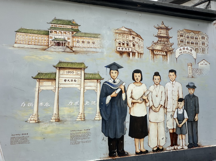
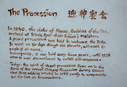
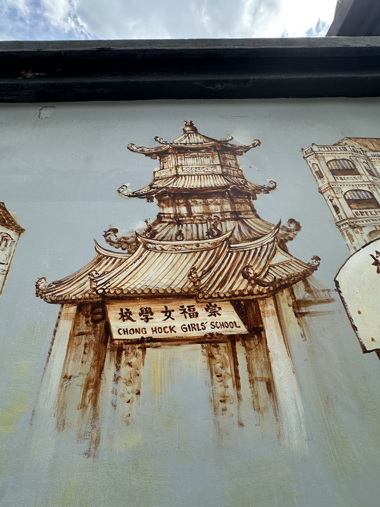
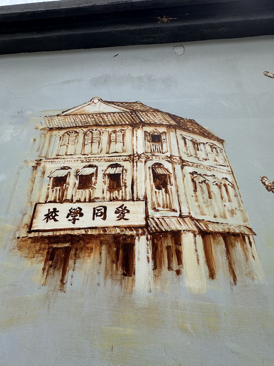
YIP SKILLS
![]()
|
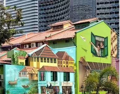
Yip Yew Chong’s Next Big Plan is to Paint the World
|
|
60 m mural
|
CHINATOWN |
|
THIEN | |
|
LITTLE RED DOT
|
|||
|
|
|||

|
|||||||||||||||||||
|
|
||||||||||||||||||||||||||||||||||||||||||||||||||||||||||||
|
THIEN HOCK KENG
|
||||||||||||||||||||||||||||||||||||||||||||||||||||||||||||
|
1980s: Beside Woodlands Checkpoint is Kampong Lorong Fatimah, a coastal village where Keretapi Tanah Melayu (KTM) trains rumble past day and night. The villagers – many KTM staff – have to pass the checkpoint to get home, and always have their identification documents on hand.
|
||||||||||||||||||||||||||||||||||||||||||||||||||||||||||||
|
1980s: One platoon defends the grounds while another attacks, during a military exercise on the long ridge of Marsiling’s hills. A looming storm threatens to end the exercise – much to the trainees’ delight. The ridge remains alongside Marsiling new town and the Seletar Expressway today.
|
||||||||||||||||||||||||||||||||||||||||||||||||||||||||||||
1980s: A hilltop village in the Sembawang-Nee Soon area overlooks the Sembwang shipyard and river prawn farms in Khatib – an unforgettable scene lost in time. Smells of farm produce, sights of village life, the whirring swoosh of RSAF Super Puma blades and the warm, swirling mist from a hot spring overwhelm the senses.
|
||||||||||||||||||||||||||||||||||||||||||||||||||||||||||||
1980s: Bukit Timah Hill – Singapore’s tallest – is rich in biodiversity. New buildings and roads were constructed using granite from quarries surrounding the hill, which ceased operations in the early 1990s. Rainwater trapped in disused quarries have since turned them into ponds and lakes.
|
||||||||||||||||||||||||||||||||||||||||||||||||||||||||||||
1980s: Thomson Road is among Singapore’s oldest North-South trunk roads. The area used to house the Police Academy and Singapore’s main TV and radio broadcaster. A drama starring Xiang Yun and Huang Wenyong is being filmed, while the Pek San Teng cemetery hills – where Bishan is today – can be seen in the distance
|
||||||||||||||||||||||||||||||||||||||||||||||||||||||||||||
.jpeg) 1980s: I have childhood memories of school excursions to the Chinese and Japanese Gardens, bird park and science centre in Jurong. As a young man, I was trained in Safti camp and attended school at Nanyang Technological University. The long bus rides, and later, journeys on the newly-opened MRT line, were especially memorable
|
||||||||||||||||||||||||||||||||||||||||||||||||||||||||||||
.jpeg) 1970s: At Haw Par Villa – a colourful, educational and scary theme park by the sea – visitors mill around, fascinated by thousands of statues. But in the park’s 10 Courts of Hell, children are literally scared as hell. Though the park’s popularity has waned, it remains a globally unique heritage site.
|
||||||||||||||||||||||||||||||||||||||||||||||||||||||||||||
.jpeg) 1980s: Pulau Seking is one of over 80 islands in Singapore’s waters. Many of the island’s inhabitants – the Orang Selat – were fishermen and workers at Pulau Bukom’s oil refineries. The islanders were relocated in 1994, before Pulau Seking was merged with Pulau Semakau to form an offshore landfill
|
||||||||||||||||||||||||||||||||||||||||||||||||||||||||||||
.jpeg) 1980s: An aerial view of Collyer Quay and Raffles Place, with a floral clock in the open square. In Change Alley, money changers and souvenir shops tout their services and goods – a sight no longer familiar, given the area’s constant and rapid change. Can you spot the buildings that remain today?
|
||||||||||||||||||||||||||||||||||||||||||||||||||||||||||||
1980s: Blue and white wooden blinds adorn some balconies in Tiong Bahru, while other windows are covered with glass, capturing the area’s modernisation over time. At the famous “bird corner” – closed in 2003 – birds sing loudly, attracting visitors from all over the world.
|
||||||||||||||||||||||||||||||||||||||||||||||||||||||||||||
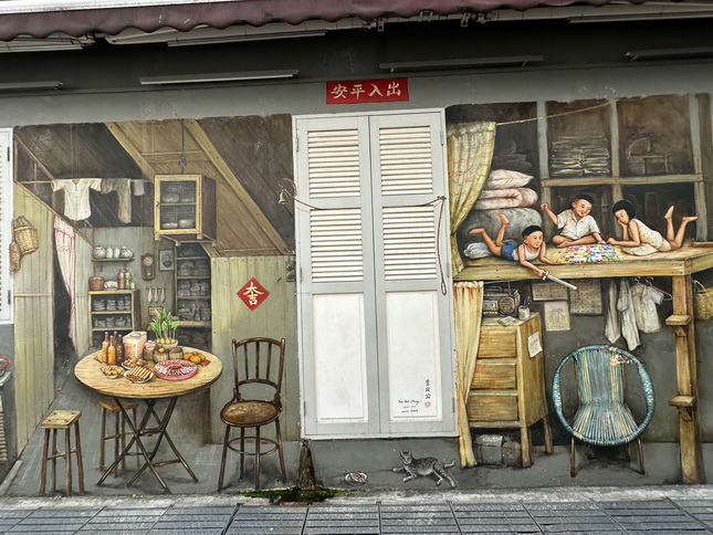
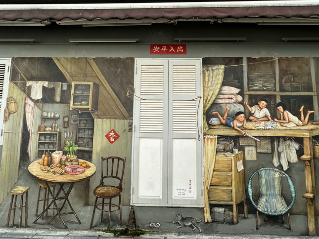
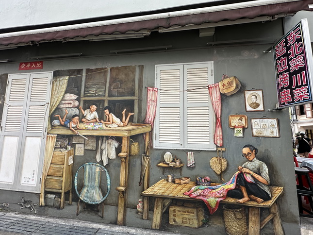
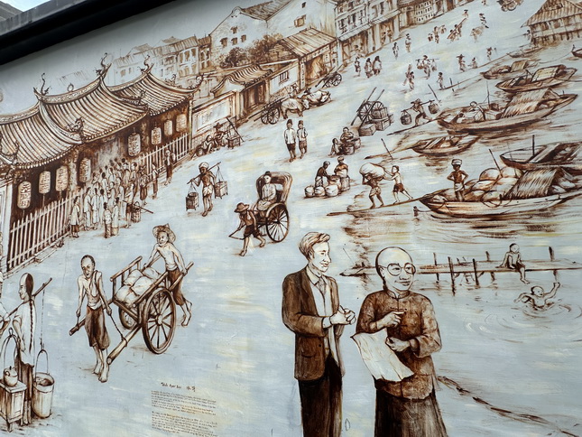
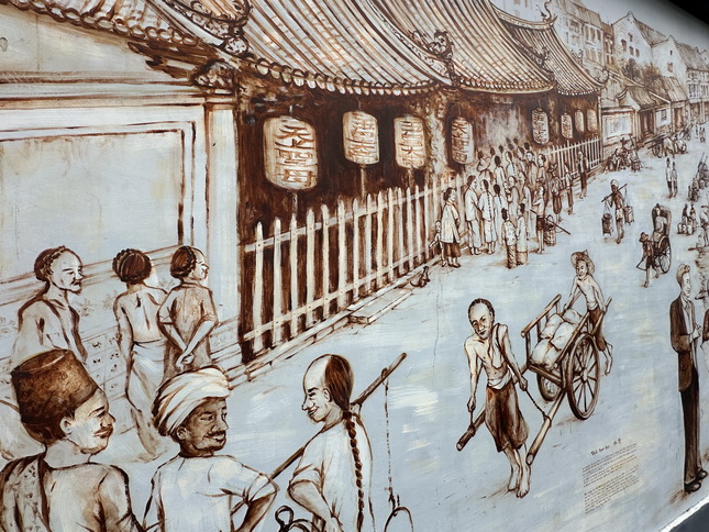
.jpeg) 1970s: I painted this last scene in January 2023, depicting an everyday, bustling scene of Kreta Ayer – where I grew up. In the kitchen, residents wash and cook, as those in the streets keep busy with trade and errands. Meanwhile, a pugilist and a lion dancer practise on a clan association’s roof.
|
||||||||||||||||||||||||||||||||||||||||||||||||||||||||||||
.jpeg)
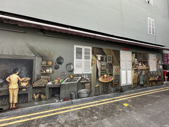
1970s: I started my 60m-long work with this panel in August 2021, which captures an enchanting night scene in Kreta Ayer, where my family lived on the second floor of a shophouse. As the main tenant, we had the luxury of windows, through which we caught street opera performances. Our sub-tenants were deeper in the building, in stuffier cubicles.Where there are entertainment performances, we cannot miss the kacang puteh (nuts) seller. Paper cones are used to pack the nuts.
|
||||||||||||||||||||||||||||||||||||||||||||||||||||||||||||
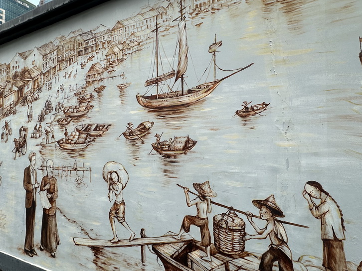
.jpeg) 1970s: As a child, I was awoken by pungent smells from the Singapore River as my school bus passed it by. Each morning, I saw the river teeming with boats, cranes and workers. Nearby, skyscrapers sprouted, each growing taller by the day. The last phase of the river’s clean-up started in 1984 – changing this scene forever.
|
||||||||||||||||||||||||||||||||||||||||||||||||||||||||||||
1970s: Near a corner of the sea-facing Padang is the popular Satay Club, a hawker centre where diners can witness traditional boat races. Around the Padang is a stately assemblage of civic buildings – joined in 1972 by the Merlion, which guards the Singapore River’s mouth. Can you spot Members of Parliament – including Mr Lee Kuan Yew – in the chamber of the former Parliament House?
|
||||||||||||||||||||||||||||||||||||||||||||||||||||||||||||
|
1980s: I spent countless weekends in the Bras Basah area, known as the world of books. There was the iconic National Library, the MPH bookstore, and a row of bookshops that lined Bras Basah Road. Trips to the area often ended with a bowl of ice kacang – irresistible to bees – at a red-roofed canteen outside the old National Library.
|
||||||||||||||||||||||||||||||||||||||||||||||||||||||||||||
|
1980s: I loved Orchard Road as a teenager – it was hip, funky and trendy. The wide boulevards and cool shopping centre atriums were great places to people-watch. There were buskers, breakdancers, “McDonald’s kids”, lost tourists, fervent shoppers and dating couples, and I loved to be among them all.
|
||||||||||||||||||||||||||||||||||||||||||||||||||||||||||||
.jpeg) 1980s: Singapore’s multiculturalism and diversity is captured in Serangoon Road, with various places of worship seen here. The area is not monoethnic, despite being named “Little India” in the 1980s for tourism promotion purposes. Colourful shops that spill onto the road make the place pulsate with energy all night long.
|
||||||||||||||||||||||||||||||||||||||||||||||||||||||||||||
|
1970s: As the fourth inland road parallel to the historical seafront, Waterloo Street is also known as “Fourth Street”. The original Guanyin, Sri Krishnan and Central Sikh temples are shown here – a great example of a multicultural Singaporean street. A night soil collection centre is depicted, and so is Sungei Road Thieves’ Market.
|
||||||||||||||||||||||||||||||||||||||||||||||||||||||||||||
|
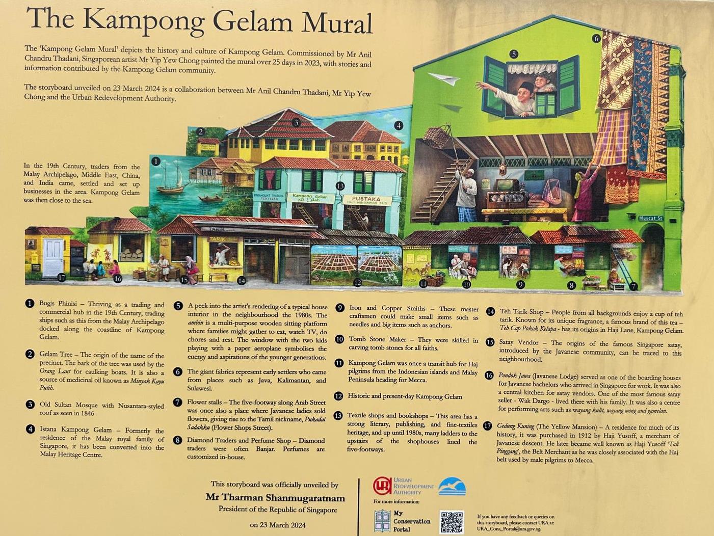
1970s: Sultan Mosque’s domes and minarets dominate Kampong Glam’s skyline. Around the mosque, streets are lined with various cottage industry specialists, such as blacksmiths, coppersmiths and tombstone carvers, as well as textile, basket and diamond traders. Hajj agencies and boarding houses serve pilgrims en route to Mecca.
|
||||||||||||||||||||||||||||||||||||||||||||||||||||||||||||
|
1970s: Farmlands stretch from Potong Pasir to Hougang, and Serangoon River in the north. The farms also surround Paya Lebar Airport, from which a supersonic Concorde takes off. It rattles the zinc roofs on land, makes the chickens and dogs run wild, while the children drop everything to watch it fly by.
|
||||||||||||||||||||||||||||||||||||||||||||||||||||||||||||
.jpeg) 1980s: Geylang Serai residents watch Malaysia Cup football, some gathered in flats with colour TVs – these scenes evoke the old kampung spirit. In a coffee shop, the cheering drowns out the rain. But in nearby Lorong 24, the mood is different – dim red lights make for a sleazy and mysterious scene.
|
||||||||||||||||||||||||||||||||||||||||||||||||||||||||||||
.jpeg)
1980s: At the void deck of a block of flats, a funeral is about to begin, as a carpark warden issues a fine. Nearby, cleaners are clearing the refuse chute, while various activities take place in a neighbouring school – classes, photo-taking and teeth-brushing. At a playground and community centre, children are having fun.
|
||||||||||||||||||||||||||||||||||||||||||||||||||||||||||||
|
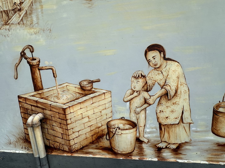
1980s: Most Singaporeans live in HDB flats, and blocks built in the early days have long corridors, where laundry is hung, doors are decorated and footwear is lined – a pair of army boots hints that a national serviceman lives here. Residents are spoilt for food choices at a hawker centre. The traditional “traffic light cakes” with red, green and amber jellies and thick butter are always distributed at weddings and baby-first-month celebrations.
|
||||||||||||||||||||||||||||||||||||||||||||||||||||||||||||
.jpeg) 1980s: This HDB town centre is inspired by those built in the 1970s and 1980s, in towns such as Toa Payoh and Ang Mo Kio. Often, a fountain is the focal point, accompanied by supermarkets, cinemas, a bus interchange and a sports complex. Here, heartland-dwellers shop, eat, play and live.
|
||||||||||||||||||||||||||||||||||||||||||||||||||||||||||||
|
1970s: Katong’s seafront is altered as land reclamation takes over the east coast area, making seaside bungalows “retreat” inland. Conveyor belts carry soil quarried from Bedok hills and Tanah Merah’s red cliffs to the coast. Bedok Reservoir emerges from a gaping hole left behind, with Marine Parade soon to rise on reclaimed land.
|
||||||||||||||||||||||||||||||||||||||||||||||||||||||||||||
|
1970s: Amid a storm, a rain-soaked Changi Village exudes an air of mystery. The ghosts of the landmark Changi Tree, Changi Hospital, and the Changi creek bridge tell spooky stories. Fret not – the wind and waves will carry all fears away.
|
||||||||||||||||||||||||||||||||||||||||||||||||||||||||||||
|
1980s: In my junior college days, I had fun camping, hiking and canoeing in the waters off Pulau Ubin and Pulau Tekong. Subsequently, I did my national service basic military training at Pulau Tekong Camp 1 in 1987. I feared “stand by bed” (bunk inspections) the most, was most worn out by the standard obstacle course, and dreaded the book-in rides on the RPL (Ramp Powered Lighter).
https://qa.st-visuals.com/2023.02.17-artwork-yip-yew-chong-2023/index.html
|
||||||||||||||||||||||||||||||||||||||||||||||||||||||||||||
| 叶耀忠甘榜格南- 新壁画。
叶耀忠甘榜格南新壁画。文字摘自叶耀忠的face book: 特色(壁画里有猫,挂历(1969-1-29)出生日期 早年,牛车水有很多老鼠,家家养猫 1979-1-29号(牛车水挂历时间)10岁时的生活”
文字摘自叶耀忠的face book: 甘榜格南也曾经是朝觐中心,来自邻国的朝圣者在乘坐轮船前往麦加之前在此过境。 来自马来群岛、中东、中国和印度的商人在该地区开展业务。
壁画的下部展示了其中一些贸易,例如纺织品和钻石贸易、书籍印刷、墓碑雕刻、铁和铜锻造。
Pondok Jawa 是朝圣者的寄宿处之一,也是娱乐中心、Wayang Kulit 表演和美食集市。
左下角是标志性的黄楼 (Gedung Kuning) 的描绘。 门旁边有两张地图——一张旧地图和一张 2023 年的地图,并排绘制,呈现出有趣的视角。 ambeng(低矮的木平台)是家庭聚会的活动中心,在这里吃饭、看电视、做家务和休息。巨大的织物代表了他们的祖先来自爪哇、加里曼丹、苏莱瓦西……最后,两个孩子在玩纸飞机的窗户象征着新一代的活力和抱负,增添了俏皮和异想天开的感觉。
|
||||||||||||||||||||||||||||||||||||||||||||||||||||||||||||
|
|
||||||||||||||||||||||||||||||||||||||||||||||||||||||||||||
|
|
||||||||||||||||||||||||||||||||||||||||||||||||||||||||||||
|
|
||||||||||||||||||||||||||||||||||||||||||||||||||||||||||||
|
|
.jpg)
.jpg)
.jpg)
.jpg)
.jpg)
.jpg)
.jpg)
.jpg)
.jpg)
.jpg)
.jpg)
.jpg)
.jpg)
.jpg)
.jpg)
.jpg)
.jpg)
.jpg)
.jpg)
.jpg)
.jpg)
.jpg)
.jpg)
.jpeg)
.jpeg)
.jpeg)
.jpeg)
.jpeg)
.jpeg)
.jpeg)
.jpeg)
.jpeg)
.jpeg)
.jpeg)
.jpeg)
.jpeg)
.jpeg)
.jpeg)
.jpeg)
可在苏丹回教堂的窗口讲解以上这些部分,再带游客们走出回教堂,
在马士吉街适合的角落集中、清点人数、继续讲解】
一面墙上描绘了甘格南早期在海滨的日子。
来自马来群岛、中东、中国和印度的商人在该地区开展业务。
壁画的下部展示了其中一些贸易,例如纺织品和钻石贸易、书籍印刷、墓碑雕刻、铁和铜锻造。
甘榜格南也曾经是朝觐中心,来自邻国的朝圣者在乘坐轮船前往麦加之前在此过境。
Pondok Jawa 是朝圣者的寄宿处之一,也是娱乐中心、Wayang Kulit 表演和美食集市。
左下角是标志性的黄楼 (Gedung Kuning) 的描绘。
门旁边有两张地图——一张旧地图和一张 2023 年的地图,并排绘制,呈现出有趣的视角。
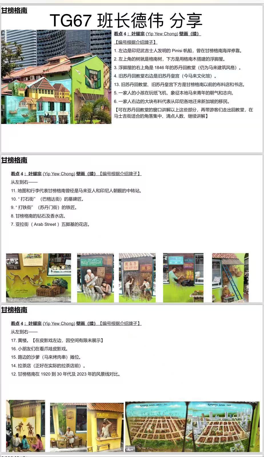
风吹日晒也在所不辞,壁画家花25天半完成最新大作-
12 Jul 2023 - to 12 Aug 2023
|
1. 左边是印尼武吉士人发明的 Pinisi帆船,曾在甘榜格南海岸停靠。 2. 左上角的树就是格南树,下方是用格南木搭建的浮脚屋。 3. 浮脚屋的右上角是1846年的苏丹回教堂(仍为马来建筑风格)。 4. 旧日苏丹回教堂右边是旧苏丹皇宫(今马来文化馆)。
|
||||
.jpeg)
.jpeg)
较高的墙壁让人们可以一睹 80 年代重建前典型房屋的内部情况。 ambeng(低矮的木平台)是家庭聚会的活动中心,在这里吃饭、看电视、做家务和休息。
两个孩子在玩纸飞机的窗户象征着新一代的活力和抱负,增添了俏皮和异想天开的感觉。 一家人的小孩在玩纸飞机,象征本地马来青年的朝气和志向
一家人右边的大块布料代表从印尼各地迁来新加坡的移民。 巨大的织物代表了他们的祖先来自爪哇、加里曼丹、苏莱瓦西……最后,
旧苏丹回教堂、旧苏丹皇宫下方是甘榜格南以前的布料店和书店。 |
||||
.jpeg) 甘榜格南也曾经是朝觐中心 |
.jpeg) 墓碑雕刻、
|
.jpeg) 铁铜锻造 |
.jpeg) 钻石贸易 书籍印刷 |
.jpeg) 纺织品 |
.jpeg)
.jpeg)
|
黄楼。【在皮影戏左边,因空间有限未展示】
|
||
.jpeg) 小朋友们在看爪哇皮影戏。 |
.jpeg) 路边的沙爹(马来烤肉串)摊位 |
.jpeg) 拉茶店(正好在实际的拉茶店前) |
|
甘榜格南在1920到30年代及2023年的风景线对比
|
||
.jpeg)
.jpg)