MOVE THE PEOPLE -
8 MRT lines by 2030 / now 6
11 expressways by 2027 / now 10 - 165kM
North-South Corridor (NSC) [to be completed in phases from 2027
![]()
|
|
|
|
(KPE - Kallang-Paya Lebar Expressway)
|
|
|
|
|
|
|
|
(MCE - Marina Coastal Expressway)
|
|
|
|
|
预计2027年
|
| 无人驾驶 | ||
| MRT MAP ENGLISH / MRT MAP CHINESE | |||
|
南北线 (NSL - North-South Line)
|
环线 (CCL - Circle Line) |
东西线 (EWL - East-West Line) |
东北线( NEL - North-East Line) |
|
滨海市区线 (DTL - Downtown Line)
|
LITTLE RED DOT
|
汤申-东海岸线 (TEL - Thomson-East Coast Line)
|
|
|
裕廊区域线 (JRL - Jurong Region Line) 2027 |
跨岛线 Cross Island Line - underground - 50 Km - 20230 |
||
|
(LRT - Light Rail Transit) |
|||

|
|
||||||||||||||||||
|
The land transport network has transformed significantly
since the inception of LTA in 1995,
with more than 160km of expressways spanning the island, MRT network of more than 200 km, 120 km of cycling paths, and increasingly varied commuting options. |
自 1995 年陆路交通管理局成立以来,陆路lùlù jiāotōng交通网络发生了重大变化, 全岛有超过 160 公里的高速公路、 超过 200 公里的捷运网络、 120 公里的自行车道以及日益多样化的通勤选择。 |
|||||||||||||||||||||||||||||||||||||||||||||||||||||||||||||||||||||||||||||||||||||||||||
|
Expressways in Singapore 1. Ayer
Rajah Expressway (AYE) |
新加坡的高速公路和隧道 1. 亚逸拉惹高速公路 (AYE) 2. 武吉知马高速公路 (BKE) 3. 中央高速公路 (CTE) 4. 东海岸公园大道 (ECP) 5. 加冷-巴耶利峇高速公路 (KPE) 6. 克兰芝高速公路 (KJE) 7. 滨海高速公路 (MCE) 8. 泛岛高速公路 (PIE) 9. 实里达高速公路 (SLE)✓ 10. 淡宾尼高速公路 (TPE) 11. 南北走廊 (NSC) [将于 2027 年分阶段完成] |
|||||||||||||||||||||||||||||||||||||||||||||||||||||||||||||||||||||||||||||||||||||||||||
|
62 米长的 Eco-Link@BKE 于 2013 年开通,为穿山甲、猴子和果子狸等野生动物提供了两处自然保护区之间的安全通道
ECP 是首批电子道路收费闸门测试和安装的地方diànzǐ dàolù shōufèi zhámén
KJE 是新加坡首批采用防滑路面的道路之一
MCE 包括一条 3.6 公里长的地下隧道,其中 420 米位于滨海湾海峡海床下。
新加坡所有开放的高速公路最高限速为90公里/小时,高速公路隧道最高限速为70公里/小时至80公里/小时。 |
The 62m Eco-Link@BKE opened in 2013 to provide wildlife
such as pangolins, monkeys and civets, a safe crossing between the two
nature reserves
The MCE includes a 3.6km underground tunnel of which 420m runs under the Marina Bay Channel seabed.
. All open expressways in Singapore have a maximum speed limit of 90km/h, and between 70km/h and 80km/h in expressway tunnels. |
|||||||||||||||||||||||||||||||||||||||||||||||||||||||||||||||||||||||||||||||||||||||||||
|
Our target is to expand the rail network to about 360km
by the early 2030s. This means connecting eight in 10 households to
within 10 minutes of a train station. With 360km of rail network,
Singapore will have a total rail length that is longer than major cities
such as Tokyo or Hong Kong today, and be on par with London and New York
City. These are some of the rail expansion projects that will bring a
train station closer to you.
|
我们的目标是到 2030 年代初将铁路网络扩展至 360 公里左右。这意味着每 10 户家庭中就有 8 户在 10 分钟内可到达火车站。有了 360 公里的铁路网络,新加坡的铁路总长度将比如今东京或香港等大城市更长,与伦敦和纽约市相当。这些是一些铁路扩建项目,它们将使火车站离您更近。 |
|||||||||||||||||||||||||||||||||||||||||||||||||||||||||||||||||||||||||||||||||||||||||||
|
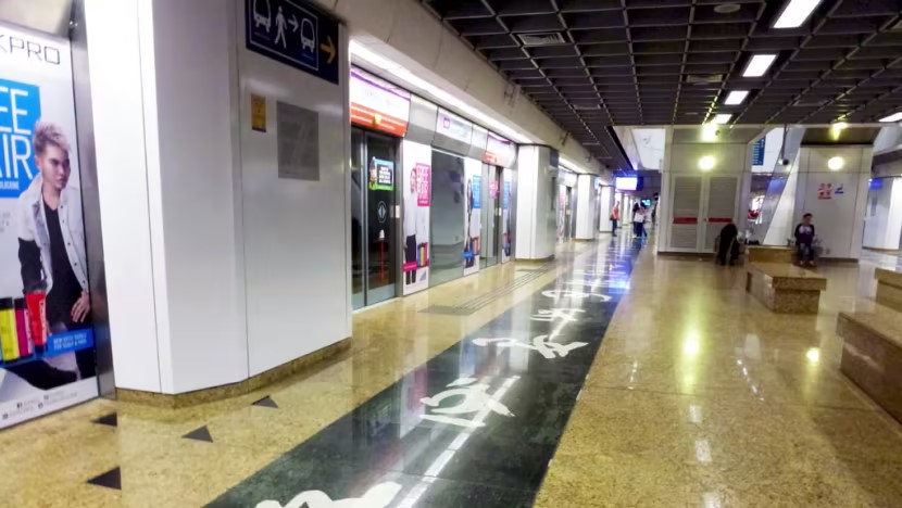
新加坡的地铁系统(MRT - Mass Rapid Transit)是新加坡公共交通的核心组成部分,由多个地铁线路构成,覆盖全国的主要地区。地铁高效、快捷,深受通勤者欢迎。 截至目前,新加坡的地铁网络包括六条主要线路,以及一条轻轨(LRT)系统,总长超过200公里。 地铁特点
以下是地铁线路的详细概述: 1. 南北线(NSL - North-South Line)
2. 东西线(EWL - East-West Line)
3. 东北线(NEL - North-East Line)
4. 环线(CCL - Circle Line)
5. 滨海市区线(DTL - Downtown Line)
6. 汤申-东海岸线(TEL - Thomson-East Coast Line)
7. 裕廊区域线(JRL - Jurong Region Line)
8. CROSS ISLAND LINE - 2030 跨岛线 - underground - -50 Km -
8. 轻轨系统(LRT - Light Rail Transit)
如果需要具体路线图、车站布局或票价信息,我可以进一步详细说明!
|
||||||||||||||||||||||||||||||||||||||||||||||||||||||||||||||||||||||||||||||||||||||||||||
|
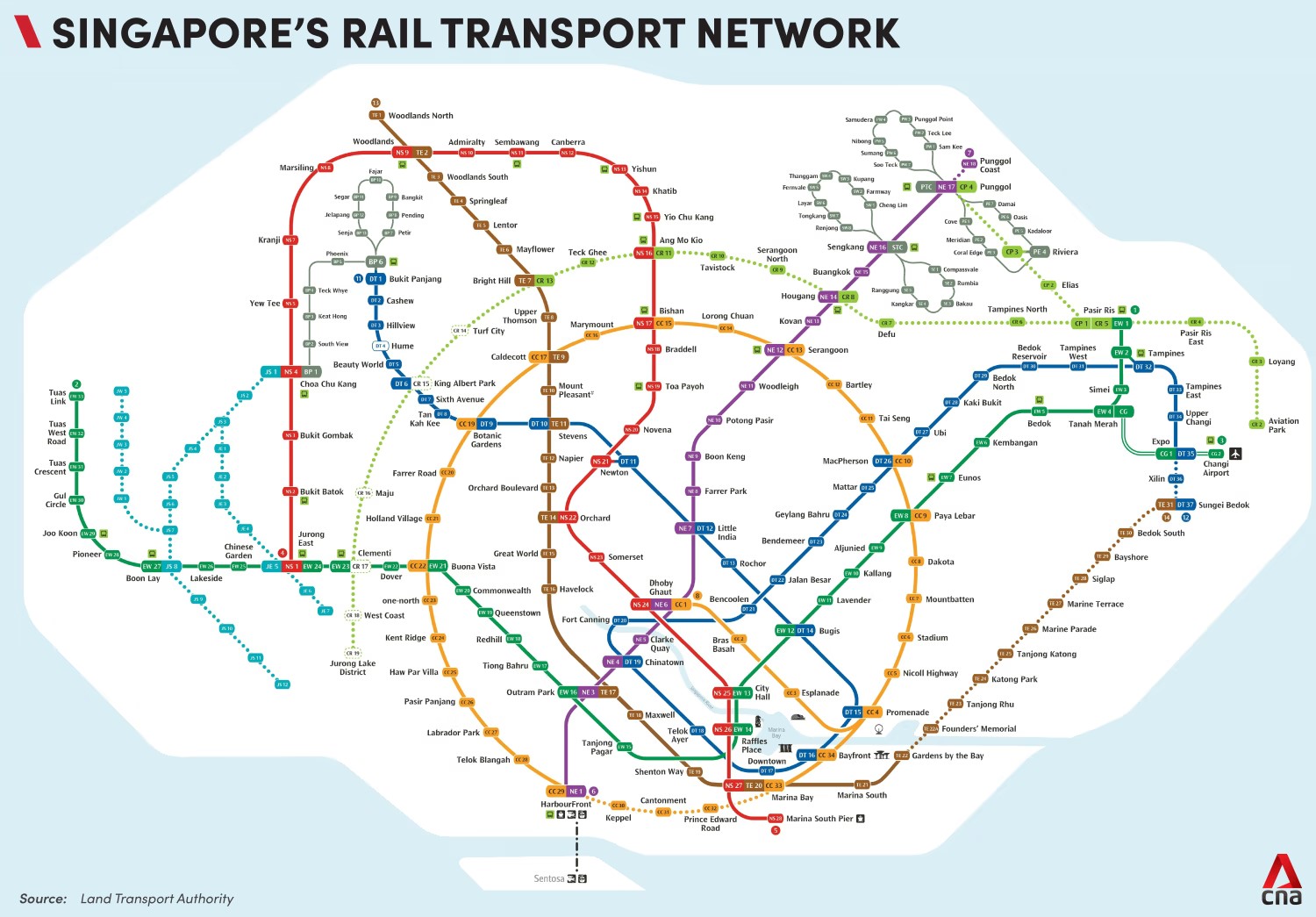
Singapore's MRT network: How has it evolved and what will it LOOK LIKE BY 2023?
Singapore’s MRT network will have eight rail lines when Phase 1 of the Cross Island Line opens in 2030. A map of Singapore's MRT network as of Jan 2023, inclusive of the upcoming stations on the Thomson-East Coast Line, Cross Island Line and Jurong Region Line that will be constructed in the coming years. (Image: Land Transport Authority)…see more
19 Jan 2023 06:07AM(Updated: 20 Jan 2023 10:55AM) Gabrielle Andres
SINGAPORE: From a mere five stations in 1987 to eight lines by 2030, Singapore’s rail network will eventually make travel times shorter and more convenient for most people. Construction of the Cross Island Line began on Wednesday (Jan 18) and Phase 1, with 12 stations, is expected to be completed by 2030. There will eventually be at least 30 stations. Once fully operational, about eight in 10 households are expected to be within a 10-minute walk of a train station, Transport Minister S Iswaran said. CNA looks at how Singapore’s MRT network has evolved through the years.
NORTH-SOUTH LINE - 45 km - 27 stations The North-South Line (NSL) was Singapore’s first MRT line, opening in 1987 with only five stations connecting Yio Chu Kang to Toa Payoh. Today, it spans 45km and has 27 stations to serve commuters travelling between Jurong East to Marina South Pier. It also includes eight interchanges, allowing travellers to transfer to the East-West Line, the Circle Line, the Downtown Line, the North East Line and the Bukit Panjang LRT. In recent years, additional stations were added: Marina South Pier in 2014 and Canberra – located between the existing Yishun and Sembawang stations – in 2019. It may be Singapore’s oldest train line, but it remains an integral part of the country’s rail system and is currently undergoing upgrading works to ensure that it keeps up with travel demands. Since the renewal works started in 2012, three out of the line’s six core systems have been replaced: The signalling system, sleepers and third rail. Track circuit replacements are also about 93 per cent complete. The bustling Jurong East MRT station was also retrofitted with two new platforms in 2012, allowing two trains to enter and depart the station at the same time. Most of the core system replacements are expected to be completed by this year, according to Mr Iswaran.
EAST-WEST LINE- 57 km - 35 stations Originally a part of the NSL, the East-West Line (EWL) is currently Singapore’s longest at about 57km. It will take you across the island, spanning 35 stations and nine interchanges from Tuas West to Changi Airport. Students may be familiar with Clementi or Dover stations, which serve nearby polytechnics and universities. The line also serves those working in the central business district, including Raffles Place, City Hall and Outram Park. Did you know that Dover MRT station was the first one to be constructed while the train line was in operation? It is also the first station to have two platforms alongside a central rail line. Like the NSL, the EWL is also undergoing a renewal of its core systems, which is set to be completed this year.
CROSS ISLAND LINE - underground - 50 Km - 2030 跨岛线 With Phase 1 set to open in 2030, the Cross Island Line (CRL) will be Singapore’s eighth and longest fully underground train line at more than 50km long. The line is key to Singapore attaining its target of having nine in 10 peak-period “Walk Cycle Ride” journeys completed in less than 45 minutes, said Mr Iswaran. Daily ridership for the Cross Island Line is expected to hit 600,000 when it opens for service in 2030, with that number eventually increasing to more than 1 million. It will take commuters through major hubs like the Jurong Lake District, Punggol Digital District and the Changi region, with more than 30 stations planned. Travelling between train lines? The CRL will have the highest number of interchange stations in Singapore, with more than half connected to existing rail stations once operational. Recreational spaces like Changi Beach Park or Bishan-Ang Mo Kio Park will also become accessible by public transport, which means family outings and daily exercise routines will be more convenient. A map of Singapore's MRT network as of January 2023, including the upcoming stations on the Thomson-East Coast Line (TEL), Cross Island Line and Jurong Region Line that will be constructed in the coming years. Three stations on TEL(*)…see more
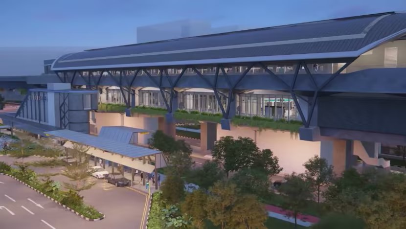
JURONG REGION LINE - 24 kn - 24 stations The Jurong Region Line, expected to be completed in 2029, will include 24 stations covering 24km. Originally slated to begin operations in 2026, construction of the JRL was stalled due to manpower shortages and materials supply disruptions brought about by the COVID-19 pandemic. It began on Jan 13.
It will be Singapore’s first fully elevated MRT line, serving five key locations – Choa Chu Kang, Jurong East, Boon Lay/Jurong West, National Technological University and the Jurong Industrial Estate. It will also serve the Tengah area, Jurong Innovation District and Jurong Lake District once fully developed. Interchange stations at Jurong East, Choa Chu Kang and Boon Lay will connect it to existing train lines. Unlike other train lines in Singapore, it will feature smaller, customised carriages that will enable the train to “easily navigate and manoeuvre through tight curves and built-up areas” along its track. Commuters using wheelchairs or strollers will also benefit from wider carriage doors and spaces, which will make rides more accessible and comfortable.
THOMSON-EAST COAST LINE - north and east - 43 km - 32 stations The Thomson-East Coast Line (TEL), which welcomed passengers to its Stage 3 stations in late 2022, will connect the eastern and northern parts of Singapore once completed in 2025. Commuters who used to take about 50 minutes to travel from Woodlands South to Orchard can now do so in 35 minutes. Consisting of 32 stations along a 43km track, the TEL is the first to feature 91 new, fully automated four-car trains, with an additional door on each car for easier boarding.
Orchard Boulevard MRT station on the Thomson-East Coast Line in Singapore that operated on Nov 13, 2022. (Photo: CNA/Hanidah Amin) Constructing the stations in the TEL marked several firsts, such as the maiden use of a retractable micro-tunnel boring machine. This was used to install internally interlocking pipes to connect the underpass across Orchard Boulevard to the TEL and NSL station platforms. An ice wall was also used for the first time to stabilise the earth prior to tunnelling works at Marina Bay station. Two more stages - Stage 4 and Stage 5 - are slated to open in 2024 and 2025 respectively. Stage 4 comprises eight stations including Tanjong Katong, Marine Parade and Siglap, while Stage 5 comprises Bedok South and Sungei Bedok stations. Founders’ Memorial, Mount Pleasant and Marina South will open in tandem with future developments. Four future stations will also include Singapore’s first underground bicycle parking facilities for those who cycle between the stations and their homes.
NORTH-EAST LINE - 16 stations The 16-station North-East Line (NEL), which connects north-eastern Singapore to heritage areas and the city fringe, marked several firsts in Singapore’s rail history. It was the first to be fully automated and driverless, as well as the first to feature artworks at its stations, with the launch of the Art-in-Transit programme that has now expanded to other rail lines. Several stations along the line – including Chinatown, Sengkang, Dhoby Ghaut and Outram Park feature artworks.
The NEL was also the first to take accessibility into account, featuring the most number of lifts at its stations at the time and the first to incorporate art into its stations. As the line serves growing neighbourhoods, many of its stations were designed to allow for future expansions to cater to the growing population. For example, when Sengkang LRT line first opened in 2003, surrounding developments were not yet built. With future connections in mind, the line's stations were built with a simple layout to allow commuters to navigate their way easily.
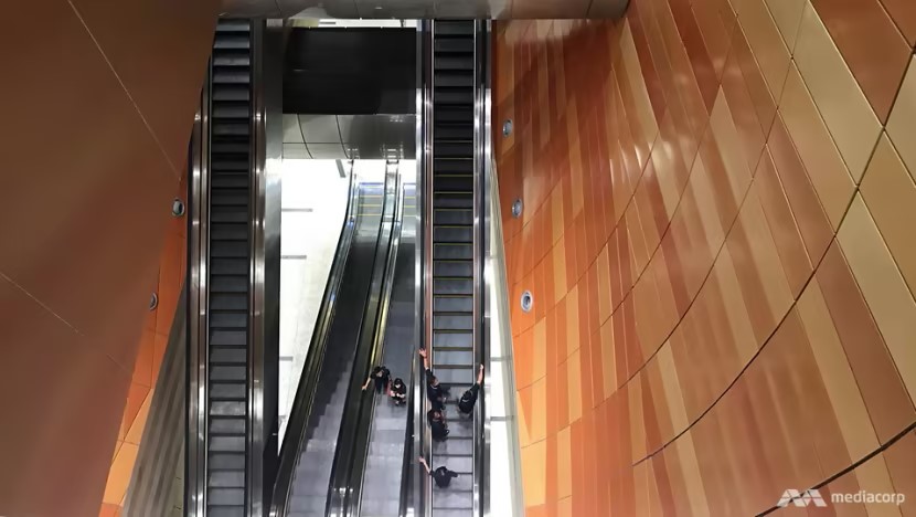
CIRCLE LINE Despite the name, the Circle Line (CCL) is not yet a full circle. Like the NEL, the 30-station CCL is completely automated and driverless. It was also Singapore’s first medium-capacity line, linking the existing NSL, EWL and NEL to the city. According to the Land Transport Authority, it required “innovations in design, engineering and construction” to build. Builders faced challenges such as varying soil conditions, which posed safety and structural issues at Promenade and Nicoll Highway stations, and having to tunnel through a maze of existing tunnels and cables. Bras Basah Station is home to the longest escalator in the MRT system, stretching 41m from the ticket concourse to the transfer level. In 2026, the CCL will become a full circle, with the opening of a 4km extension that includes three stations connecting HarbourFront to Marina Bay. Commuters will enjoy a direct route between areas in the west - such as Pasir Panjang and Kent Ridge - and the Central Business District. Those living in Paya Lebar and Mountbatten will also get faster access to the HarbourFront area.
DOWNTOWN LINE Measuring 42km and covering 36 stations, the Downtown Line (DTL) is Singapore’s longest underground and driverless MRT line. It serves residential areas in Bukit Panjang, Bukit Timah, MacPherson and Bedok Reservoir, which were previously not covered by the MRT system.
Bencoolen station is the deepest station in Singapore at 43m below ground. (Photo: Elizabeth Neo) Construction on Singapore’s deepest rail line also came with several firsts. For instance, builders had to temporarily divert the Singapore river to safely connect Fort Canning and Chinatown stations. This entailed a process to reroute the river and pack the section above the planned tunnel route with soil to safely excavate the tunnels. Builders also had to balance safety, structural stability and other issues to dig to a depth of 14 storeys to link Bencoolen and Fort Canning MRT stations. At 43m below street level, Bencoolen is the deepest station in Singapore. Diggers had to use tunnelling machines and explosives to clear the ground, as they were digging through “soil as soft as toothpaste, mixed with giant hard rocks”. Added precautions were taken to ensure safety and ground stability. Commuters travelling to areas such as Changi Business Park and the Expo area can look forward to better accessibility in 2024, when an extension to the DTL will allow them to connect to the TEL.
|
||||||||||||||||||||||||||||||||||||||||||||||||||||||||||||||||||||||||||||||||||||||||||||
|
备注:有关交通工具 1. 地铁:旅客通行卡(S'pore Tourist Pass) 1 day pass $17, 2 day pass $24 3 day pass $29(可无限次乘坐巴士和地铁)剩余退款在T2和T3可以办理
2. 计程车:所有计程车都有计程表,在特定的时间、地点,不同公司的计程车会收取额外的费用 3. 公共巴士:易通卡或TouristPass都可以使用
|
||||||||||||||||||||||||||||||||||||||||||||||||||||||||||||||||||||||||||||||||||||||||||||
|
|
||||||||||||||||||||||||||||||||||||||||||||||||||||||||||||||||||||||||||||||||||||||||||||
| Singapore's Expressways form an efficient road network designed to
connect various regions across the country and facilitate traffic flow. These expressways are managed by the **Land Transport Authority (LTA)** and are of closed design, without traffic lights, and connected to other major roads and areas through exits. As of now, Singapore has ten major expressways with a total length of about 165 kilometers.
Here is an overview:
10. Kranji Expressway (KJE) 11. North-South Corridor (NSE - North-South Corridor, under
construction)
|
||||||||||||||||||||||||||||||||||||||||||||||||||||||||||||||||||||||||||||||||||||||||||||
|
||||||||||||||||||||||||||||||||||||||||||||||||||||||||||||||||||||||||||||||||||||||||||||
|
ERP 系统通过设置在道路上的传感器来自动收费,驾驶员不需要停下来缴费。jiǎofèi. 这些费用根据不同时间段的交通流量来动态调整,以缓解交通拥堵yǒng dǔ。收费系统主要覆盖fùgài高峰时段和繁忙的路段。
|
The default and national speed limit for
Singapore's highways is 90km/h, but lower speed limits such as 80km/h or
70km/h are used in some areas, especially in urban areas, tunnels, busy
traffic areas and crosswinds. Singapore uses an electronic road pricing system (ERP) to collect tolls on some roads. The ERP system automatically collects tolls through sensors set on the road, and drivers do not need to stop to pay. These fees are dynamically adjusted according to traffic flow at different time periods to alleviate traffic congestionB. The toll system mainly coversA peak hours and busy sections. Singapore attaches great importance to environmental protection when building highways, and minimizes the impact on the ecological environment as much as possible. Many highways have green belts next to them, and even set up ecological bridges and tunnels to ensure that animals can cross safely. In addition, Singapore also encourages the use of electric vehicles and provides charging facilities to reduce pollution to the environment. |
|||||||||||||||||||||||||||||||||||||||||||||||||||||||||||||||||||||||||||||||||||||||||||
| 无人驾驶
滨海湾和珊顿道,以及纬壹科技城将从明年中起,试验推行无人驾驶小型公共巴士计划。
|
The pilot program for driverless mini
buses will be implemented in Marina Bay and Shenton Way, as well as the
one-north from mid-next year. |
|||||||||||||||||||||||||||||||||||||||||||||||||||||||||||||||||||||||||||||||||||||||||||
 An
artist impression of a Jurong Region Line (JRL) station in Tengah Town.
(Image: LTA)
An
artist impression of a Jurong Region Line (JRL) station in Tengah Town.
(Image: LTA)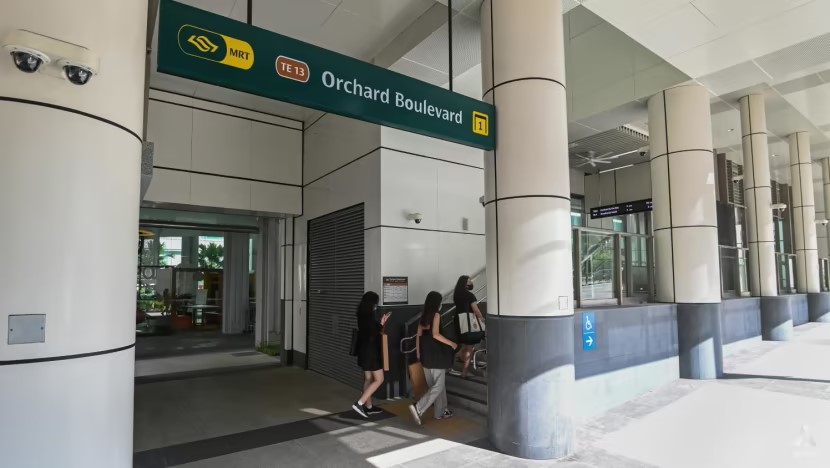
 The
Phoenix's-Eye Domain, an artwork located at Chinatown MRT Station.
(Photo: LTA)
The
Phoenix's-Eye Domain, an artwork located at Chinatown MRT Station.
(Photo: LTA)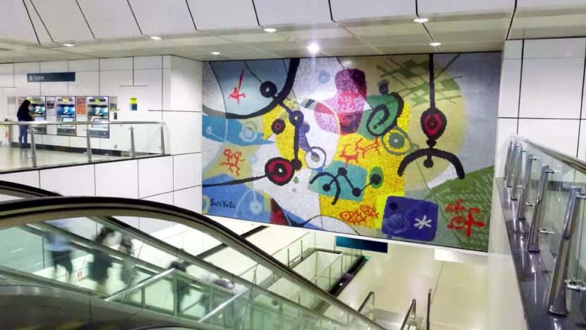 Universal
Language, an artwork located at Dhoby Ghaut MRT Station. (Photo: LTA)
Universal
Language, an artwork located at Dhoby Ghaut MRT Station. (Photo: LTA)