SINGAPORE STORY - THE NEXT GEN
SINGAPORE STORY

|
THE NEXT GENERATION
|
| Long Island |
|
The Turf City | Paya Lebar | |
|
|
Marina
Square –
|
SENTOSA |
|
RTS – Johor |
|
|
|
Jurong Island | T5 Airport | |
| Future land |
|
LITTLE RED DOT
|
|||
|
|
|||


|
Singapore as a city-state-country with no sovereign hinterland- faces a unique geographical constrains on land, resources and nature. We have to pack so much on this little island with precise integrated national infrastructure plan- above ground and under ground to meet the long term needs for transport, green plans, digital connectivity, water , energy and public spaces , parks , education, social and housing and sustainable growth over time. Building people cities to enable communities to thrive and evolve over time. Just on this little island, we have one of the largest containers port in the world, we housed 17 reservoirs and many catchment forests and the 18th at Long Island coming up and is a first step to combat climatic change due to rising sea levels. We are also reinventing out tourist destinations and attractions to enable every visitor to Singapore to have a memorable experience. The future story will be written differently as we face an aging Population, lowering Total Fertitlity Rate, Disrupting technologies from Internet of things and virtual reality VR store now into generative AI to agentic AI and technological driven on demand and social – push platforms and e commerce driven by algorithm. We face rapid changes and our transformation and realignment must be fast enough. These trends and disruptions are all converging on Singapore. With the Long Term plan to take all these evolving trends and a Master Plan that reviews every 5 years, we continually refined the needs of the day to ensure their relevance, and is driven by the whole of government and respective agencies- where assumptions, feedback and projections and strategies are adjusted from time to time. Future mega reclamation projects were announced recently and future nuclear energy approaches are also studied. We need to re-imagine and go beyond our constraints. We have reimagine the city and bring City in Nature and now we creating more land our of the seas in our western and southern islands and improving the connectivity eg tunnels to Pulau Tekong. Going forward, Singapore has several long term development project such as T5 extensions, Jurong Island, Long Island in east coast, Great Southern Waterfront including Marina South in south coast, Cross Island Line, N-S corridor highways Punggol Digital District, Paya Lebar Development, ... as well as RTS to Johore Baru. Housing is at the core of planning as 80% in HDB abd 90% owned their flats- and affordable housing and rising cost of housing as we have prime and plus, and moving up the ladder of demands for smart architecture, smart estate management and monitoring of all resources, waste and with sensors and big data analytics to drive efficiency , smart enabled homes for living Please explain these developments, their purpose, phasing and how they will contribute to different strategic purposes and what is the future plans and things that we can expect as well Nice list — Singapore’s next-generation plans are all about squeezing value from scarce land while boosting resilience, connectivity and high-value jobs. What these projects add up to — strategic picture
Practical expectations (what to look for, and when)
Quick timeline summary (high-level)
Below I’ll summarize
each project you named (purpose, phasing/what’s happening now, strategic
role) and finish with short “what to expect” takeaways and timing notes.
I’ve used official planning and agency sources for the key facts. 2. Greater Southern Waterfront (including Marina South / Keppel area) 3. The Turf City Transformation 4. Paya Lebar Airport 5. Marina Bay Sands – IR2 6. Marina Square – redevelopment 7. Sentosa 8. Cross Island Line 9. RTS – Johor 10. Punggol Digital District 11. N parks andSustainability Journey 12. Jurong island 13. T5 14. Future land Reclamation
|
||||||||||||||||||||||||||||||||||||||||||||||||||||||||||||||||||||||||||||||||||||||||||||||||||||||||||||||||||||||||||||||||||||||||||||||
|
Long Island” (East Coast reclamation) — flood, water and land supply solution “Long Island” (East Coast reclamation) — flood, water and land supply solution
Purpose:
large reclamation concept (about ~800 ha) off the east coast
designed to: (1) provide a flood-defence / coastal buffer against
sea-level rise, (2) create a new reservoir to strengthen water
resilience, and (3) add long-term developable land for future needs.
Urban
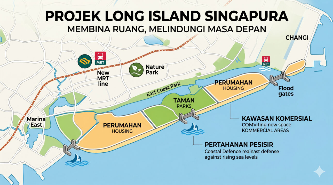
Redevelopment Authority Singapore’s Long Island is a long-term coastal-protection, land-reclamation and water-resilience project along the East Coast, extending broadly from Marina East to Tanah Merah. The current concept involves reclaiming about 800 hectares of land—roughly twice the size of Marina Bay—while creating a new freshwater reservoir and approximately 20 km of new waterfront parks.ura.gov+2 Main purpose Long Island is intended to serve several purposes at the same time:
The project is not intended to be a single narrow island in the conventional sense. Current planning describes three reclaimed land tracts, separated by controlled water passages and linked to the mainland at strategic points. Main components 1. Three reclaimed land tracts The proposed Long Island would consist of three elevated areas of reclaimed land arranged offshore, broadly parallel to the existing East Coast. Their potential roles are expected to differ:
These land-use descriptions are planning possibilities rather than final approved land-use plans. The government has emphasised that detailed planning, engineering and environmental work must be completed before the final layout is fixed.ura.gov+1 2. New freshwater reservoir The reclaimed tracts would enclose a large water body between the new land and the existing East Coast shoreline. Over time, this water body could become a new freshwater reservoir, potentially Singapore’s 18th reservoir.channelnewsasia The reservoir would be supported by:
3. Coastal-defence system The reclaimed land would be formed at a higher level than the present coastline, creating a continuous line of defence in front of East Coast Park. The system would combine:
This approach could
reduce reliance on a continuous high seawall immediately beside East
Coast Park, allowing the existing coastline to remain more accessible as
a public waterfront. 4. Parks and waterfront spaces The completed project is expected to provide about 20 km of waterfront parks and public spaces. These could include:
The exact park layout has not yet been finalised. 5. Transport and urban connections Long Island could eventually require new roads, public-transport links and pedestrian or cycling connections. The concept is intended to improve the relationship between:
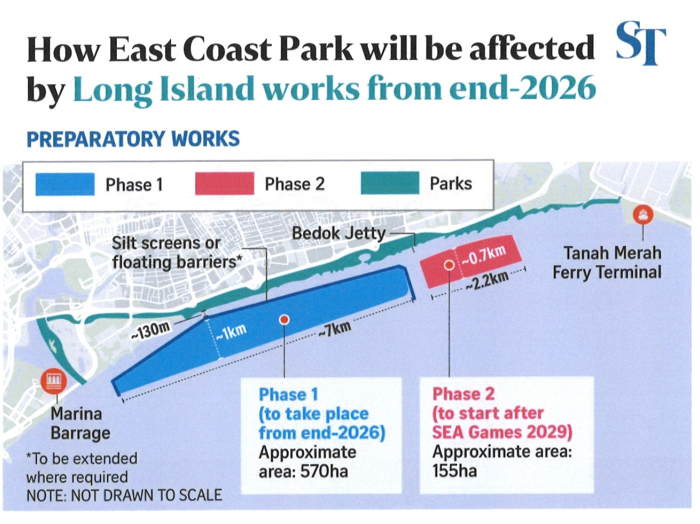
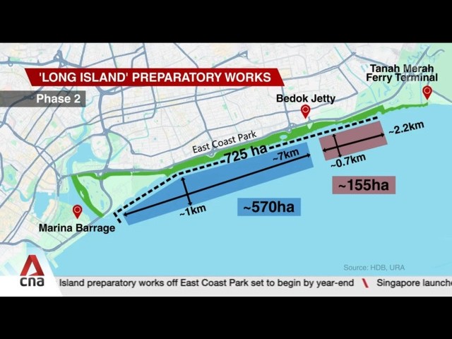
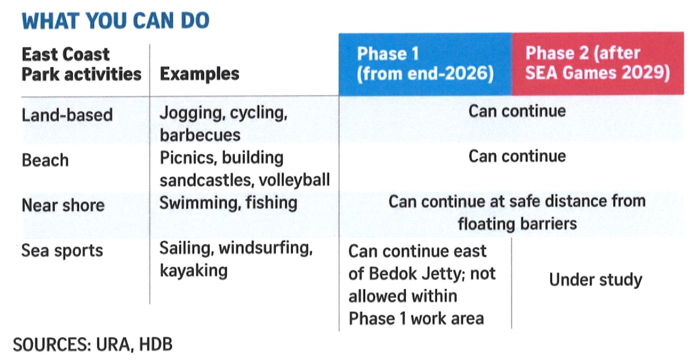
However, specific rail lines, road alignments and development densities remain subject to future planning studies. Phasing It is useful to distinguish between the preparatory works now announced and the much larger main Long Island development. Phase 1: Preparatory works west of Bedok Jetty The first preparatory phase is scheduled to begin from the end of 2026 in the waters west of Bedok Jetty. It will cover approximately:
The works will involve:
This is a preparatory marine-works area; it should not be confused with 570 hectares of completed urban land.ura.gov+1 Phase 2: Preparatory works east of Bedok Jetty The second preparatory phase will take place east of Bedok Jetty and cover approximately:
It is planned to begin after the water areas are no longer required for the 2029 Southeast Asian Games, subject to the detailed programme and approvals.ura.gov+1 Together, the two currently announced preparatory-work areas total approximately:
The 725-hectare figure represents the current preparatory-work footprint, while the eventual Long Island reclamation is described more broadly as about 800 hectares.ura.gov+1 Phase 3: Main reclamation and coastal infrastructure After preparatory works and further technical studies, the project would proceed progressively with:
The government has
indicated that Long Island will take a few decades to plan,
design and implement. The exact construction sequence, land-use
programme and opening dates have not yet been confirmed.ura.gov+1 Land and reservoir sizes
The size of the reservoir has not yet been officially published as a final figure in hectares or cubic metres. This is because the final shoreline, spacing of the three reclaimed tracts, reservoir depth, drainage catchment and tidal-gate arrangement are still being studied. Official sources currently describe the reservoir concept and its flood-management function, but do not provide a confirmed reservoir surface area or storage volume.ura.gov+1 Practical interpretation In simple terms, Long Island can be understood as a three-part offshore coastal platform: text Existing East Coast Park │ │ New freshwater reservoir │ controlled by barrages and pumps │ ┌──────┴────────┐ ┌──────────────┐ ┌───────────────┐ │ Tract 1 │ │ Tract 2 │ │ Tract 3 │ │ Marina East │ │ East Coast │ │ Changi side │ │ mixed-use │ │ parks/leisure│ │ future hub use│ └───────────────┘ └──────────────┘ └───────────────┘ │ Protected higher-level coastal defence The important qualification is that this remains a long-term concept under technical development, not a fully fixed master plan. The 800-hectare land figure is established as the broad project scale, but the final reservoir size, exact land-use zoning, transport network and construction sequence remain subject to engineering studies, environmental assessment and public consultation.
|
||||||||||||||||||||||||||||||||||||||||||||||||||||||||||||||||||||||||||||||||||||||||||||||||||||||||||||||||||||||||||||||||||||||||||||||
|
Greater Southern Waterfront (including Marina South / Keppel area) Greater Southern Waterfront (including Marina South / Keppel area) — new city living + jobs on the southern shoreline
Purpose:
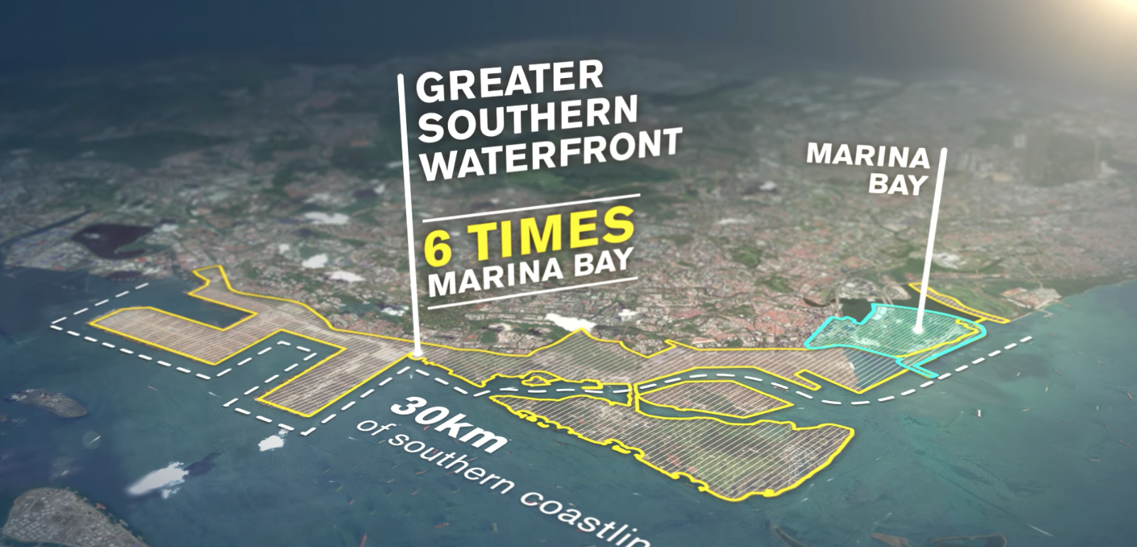
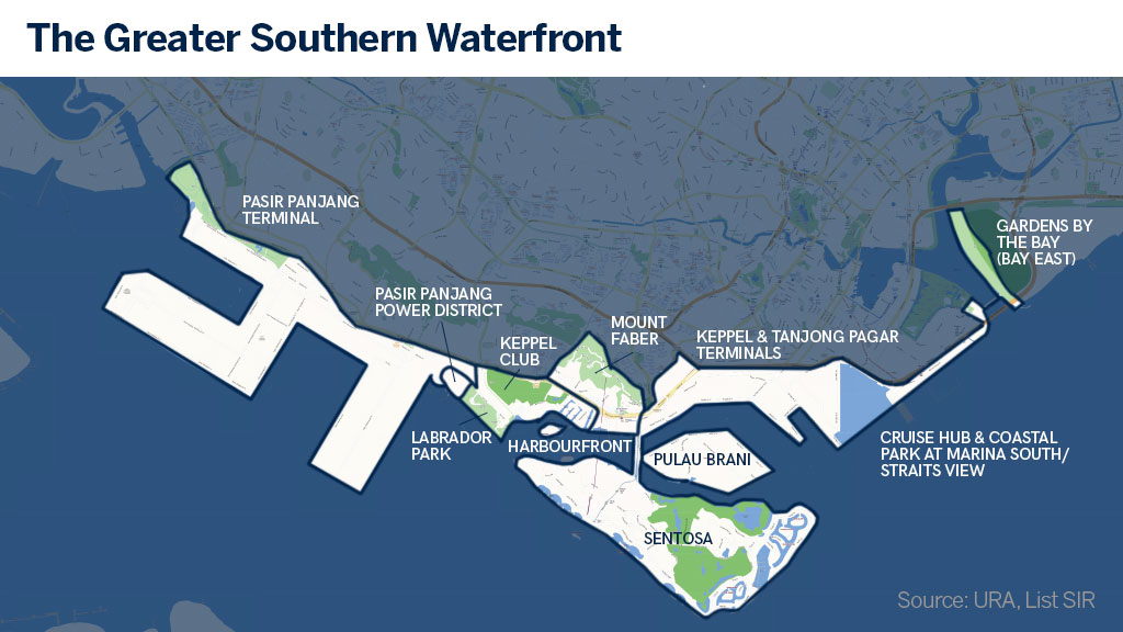
transform ~30 km of southern shoreline (from Marina Bay to Pasir Panjang)
into mixed waterfront living, recreation and business precincts — open
up prime waterfront for housing, leisure and business clusters.
URA
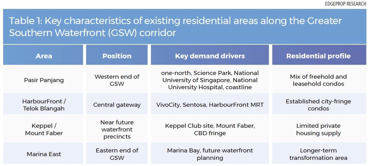
Draft Master Plan+1 Stretching over 2,000 hectares of land which is about six times the size of Marina Bay, the GSW is poised to be a key game-changer precinct that will cement Singapore’s quest to be a Southern Gateway of Asia, which will be fully realised with a long-term planning of over 10 to 20 years. Possibilities of creative land use zoning across GSW are aplenty and having certain degree of flexibility in development planning, while retaining the overarching goals of progressive urban solutions, will be essential for future real estate to keep up with market trends.
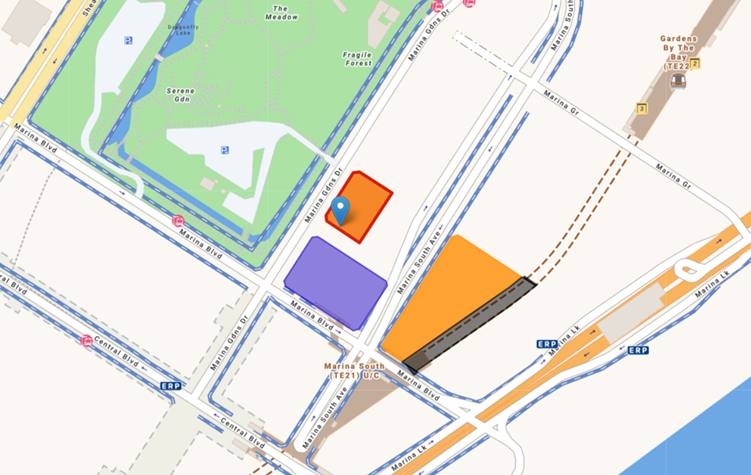
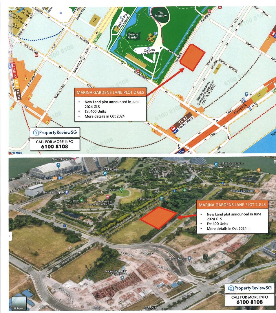
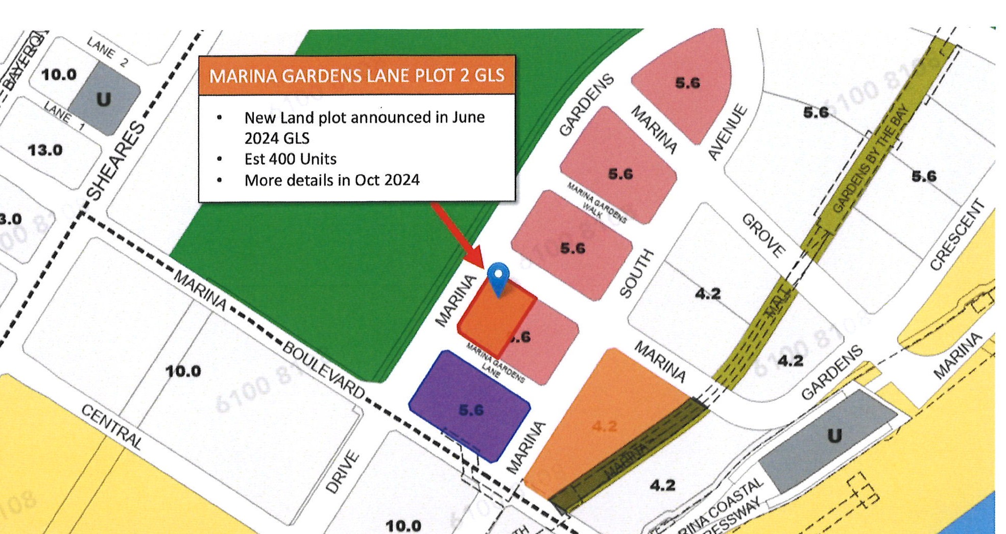
MARINA SOUTH The Marina Gardens Lane site is the third to be launched for sale in the Marina South precinct, following two earlier parcels.
The first was a white site at Marina Gardens Crescent, which went unawarded after its sole bid of nearly $770.5 million, or $984 psf ppr, was deemed too low by URA in February 2024.
The other was a mixed-use site at Marina Gardens Lane under the 2H 2022 GLS programme, which was awarded to a Kingsford-led consortium in July 2023 for $1.034 billion, or $1,402 psf ppr. It was subsequently launched as One Marina Gardens in12 April 2025 and sold 356 units out of 937 units @$2,953 psf ( 38%)
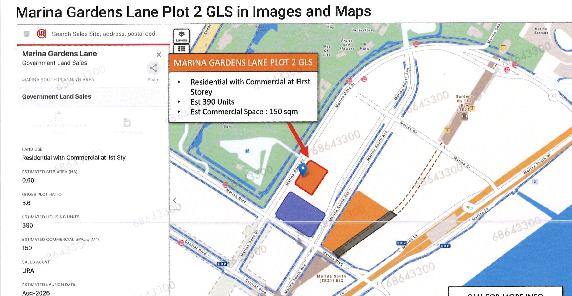
The Urban Redevelopment Authority (URA) has released two residential sites at Marina Gardens Lane and Orchard Boulevard for sale under the second half 2026 (2H2026) Government Land Sales (GLS) Programme. The sites at Marina Gardens Lane (located near Marina South MRT station) and Orchard Boulevard (located near Orchard Boulevard MRT station) can potentially yield about 390 and 110 residential units, respectively. These form part of the 4,745 residential units to be released via the Confirmed List of the 2H2026 GLS programme, which is more than 50% higher than the annual average Confirmed List supply over the past 10 years. The tender for the Marina Gardens Lane and Orchard Boulevard sites will close at 12 noon on 15 October 2026 and 29 October 2026, respectively. The latest Marina South parcel (Marina Gardens Lane Plot 2)is slated to be a 99-year leasehold residential development with a commercial component on the first floor, also benefits from proximity to Gardens by the Bay MRT station and the eventual Marina South MRT station, both on the Thomson-East Coast Line. Residential development with commercial at 1st storey | Tender submission: 15 October 2026, 9.00 am - 12.00 pm
Although the site is significantly smaller, at roughly 6,000 sq m (0.60 ha), compared with 12,245 sq m for its 2H 2022 GLS predecessor, this could be seen as advantageous for smaller and mid-sized developers seeking a foothold in the RCR. Due to its size, smaller players may find the site attractive as it is likely to result in a lower bid quantum, and hence, lower development risk. As a result, we could see a similar level of competition, with around four bidders for this site down the road.
PASIR PANJANG
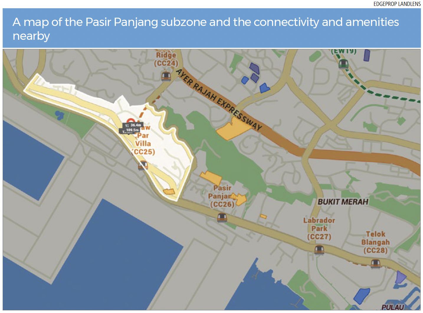
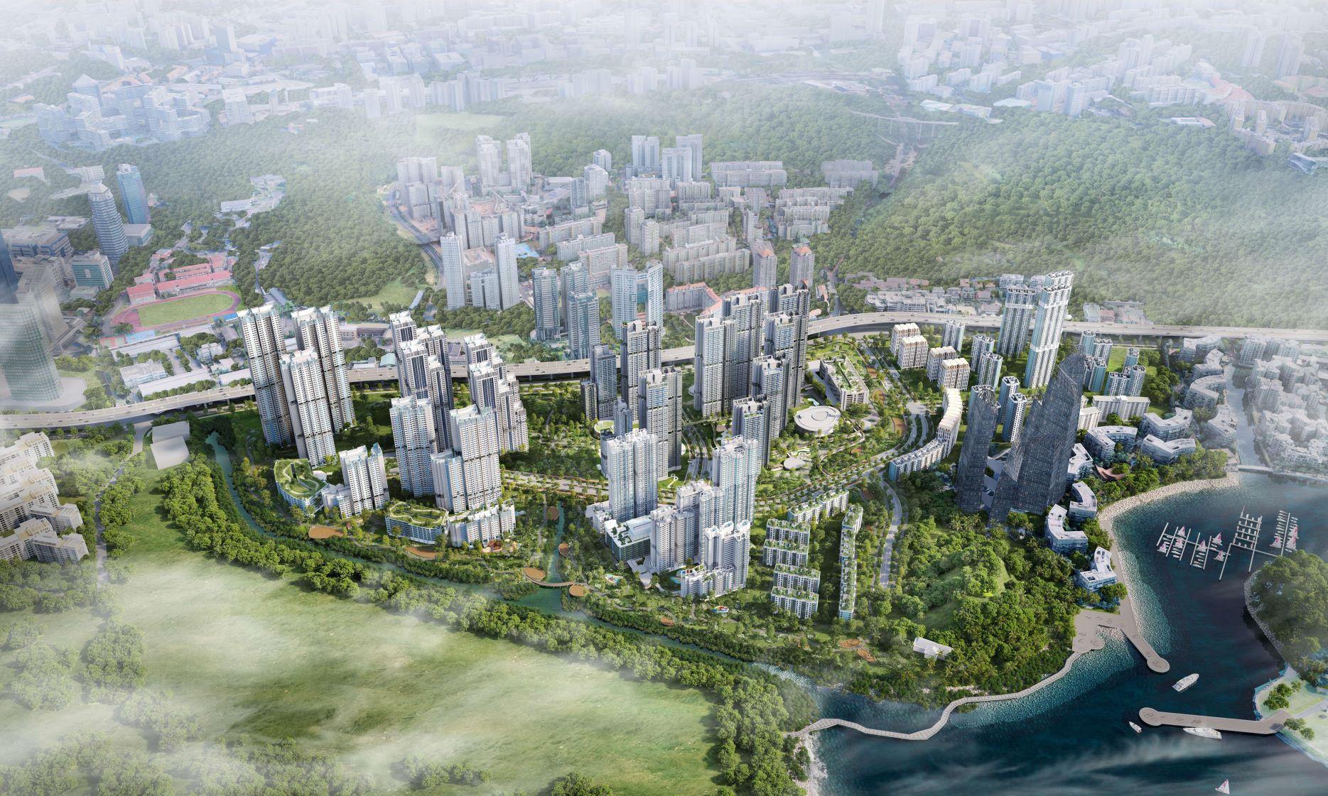
KEPPEL GOLF COURSE - REDEVELOPMENT The future redevelopment of the former Keppel Golf Course at Berlayar is a significant part of Singapore's Greater Southern Waterfront transformation, set to deliver a mix of public and private homes with a focus on waterfront living and nature integration .
The Government Land Sales (GLS) parcels in the new Berlayar estate on the former Keppel Club site include the Telok Blangah Road plot (awarded at $1,326 psf ppr) and the Berlayar Drive plot (awarded at $1,515 psf ppr). They form part of the Urban Redevelopment Authority Greater Southern Waterfront master plan. [1, 2, 3, 4] Parcel Details
🏗️ First Two GLS Land Parcels: A Comparison Here are the key details for the first two private residential sites offered in the new Berlayar estate:
🏡 HDB Intention, Type of Flats, and Conditions The HDB's plan is to build a substantial number of public housing flats in the Berlayar estate, creating a vibrant, inclusive community with a mix of housing types.
📅 Phasing of HDB Projects The public housing in Berlayar is being rolled out in phases.
Given the keen interest, do you want to know more about the specific flat classifications (Prime/Plus) or the amenities planned for the Berlayar estate?
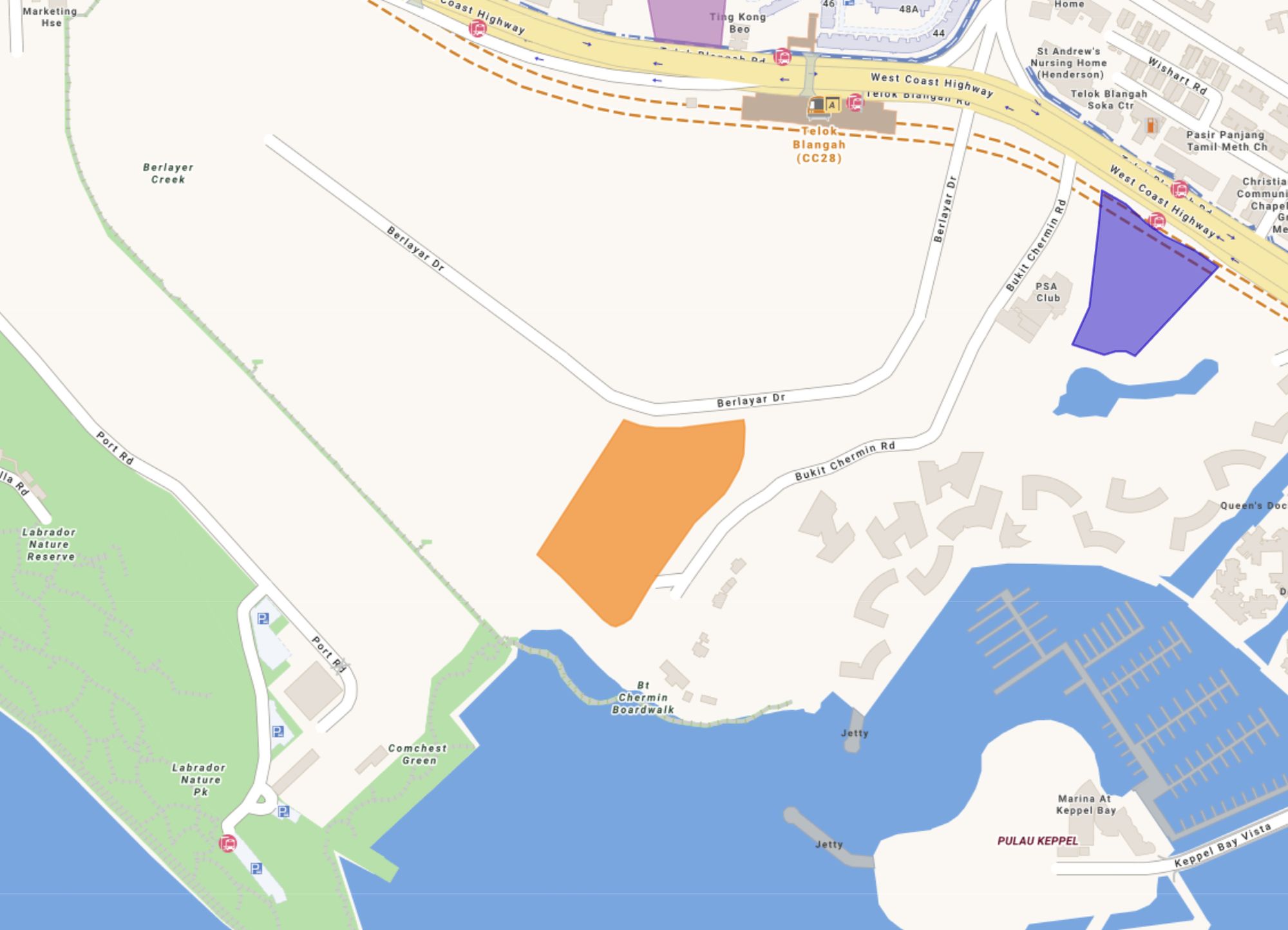
Berlayar Drive is one of the most unique GLS sites in recent years The Berlayar estate The Berlayar estate, a mix of public and private residential neighbourhood, is on the site of the former Keppel Golf Course, which vacated it in 2022. (Map: URA) Overall, the GLS site on Berlayar Drive is relatively small at 271,929 sq ft with a gross plot ratio (GPR) of 1.4. Thus, the new development is only expected to yield only around 415 new homes. This is less than the typical number of condo units that we usually see in a mid-sized development, which usually features a mix of 500 to 600 units. However, the plot is unique. This site, along with other upcoming plots in this new Berlayar neighbourhood, was where the former Keppel Golf Course used to be located. The golf course vacated this area in 2022. This area is close to Labrador Nature Reserve, Mount Faber, and Sentosa. The transformation is part of the Greater Southern Waterfront (GSW) masterplan, which stretches from Pasir Panjang to Marina East. The 2,000 ha GSW is set to reshape Singapore’s southern coastline with new residential neighbourhoods, commercial spaces, and recreational amenities. Now, with the launch of this GLS site at Berlayar Drive, it will be the first opportunity for developers to secure an early foothold within the GSW, says ERA Singapore CEO, Marcus Chu. He adds that it is extremely rare for new development sites in this area to hit the market, which will likely boost the appeal of the GLS site among developers. However, the GLS site comes with a relatively low GPR, and the new development will feature residential blocks of up to five-storeys. But this could be to its advantage since it means that there will be fewer developments blocking the prime waterfront view. 1 Aerial with clouds The Barlayar estate will feature 7,000 new flats and 3,000 new condo units. (Picture: URA)
The development of the Berlayar housing estate will feature a mix of private and public housing, and new amenities including supermarkets, shops, clinics, and preschools, in order to improve the area’s long-term liveability. Recent project launches in city-fringe locales – also known as the Rest of Central Region (RCR) – have recorded strong take-up rates in recent months, such as Zyon Grand and Promenade Peak in River Valley, as well as Penrith along Margaret Drive. Realion Group Deputy CEO Justin Quek says that lower inventory levels across sub-markets in the RCR could further support buying interest for new projects in well-located areas such as the Berlayar estate. That area also benefits from its proximity to several business nodes, such as HarbourFront Centre and Mapletree Business City. Next to the Berlayar estate is Telok Blangah MRT station on the Circle Line (CC), which is one stop away from Harbourfront MRT Interchange on the CC and North East Line – and directly linked to VivoCity shopping mall. All these attributes means that most market watchers expect the GLS site at Berlayar Drive to attract a high level of developer participation when the tender closes on Aug 4. Realion expects between four and seven bidders for the site, with a top bid that could range from around $1,400 to $1,500 psf per plot ratio (ppr). Therme Group Two major international spa/wellness groups have recently entered or are entering Singapore: 1. Therme Group (European – the biggest one)At Marina South (waterfront site next to Marina Barrage / Gardens by the Bay area).This is the most significant new international wellness/spa group coming to Singapore.
Key attractions & facilities:
It will serve as Therme’s gateway to Asia. Therme Group → Massive thermal spa & water park-style wellness complex (Marina South, 2030)
|
||||||||||||||||||||||||||||||||||||||||||||||||||||||||||||||||||||||||||||||||||||||||||||||||||||||||||||||||||||||||||||||||||||||||||||||
|
The Turf City Transformation
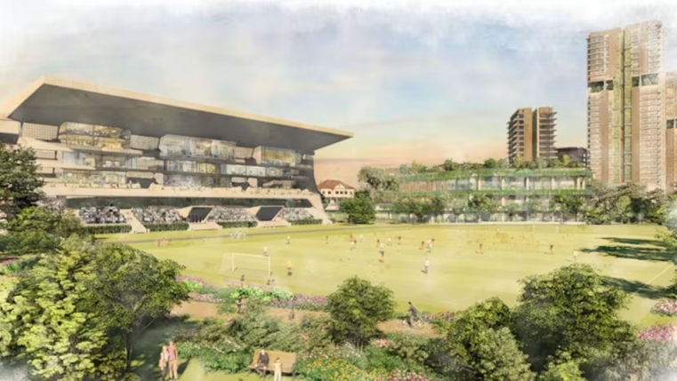
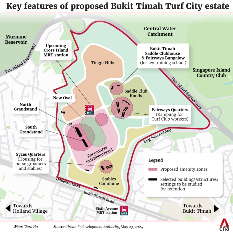
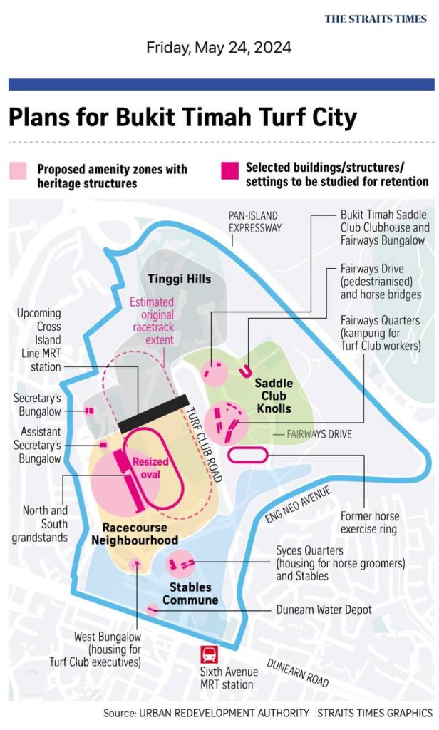
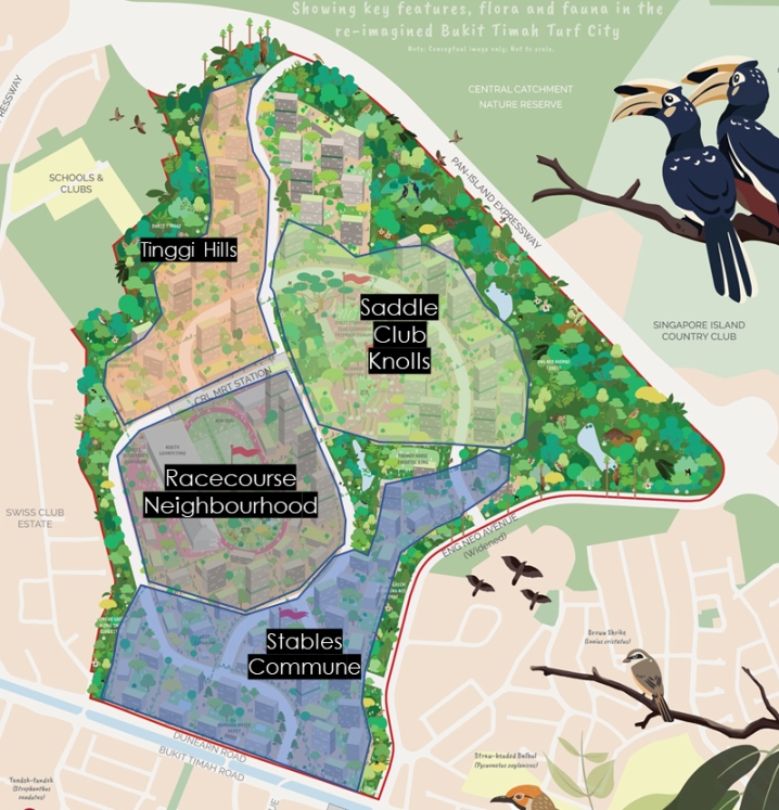
The Turf City redevelopment is a major, multi-decade project to transform the former racecourse site into a new residential estate integrating heritage, nature, and modern amenities. The vision is to create a "people-centric, pedestrian-friendly and car-lite" community with 15,000 to 20,000 public and private homes over the next 20 to 30 years . The development is being carefully planned to preserve the area's historical and ecological significance .
The
first two Government Land Sales (GLS) sites, both located along Dunearn
Road, mark the start of this transformation .
🏗️ First Two GLS Sites: A Detailed Look Here are the key details for the two awarded sites:
🗺️ Future Development Plan The long-term master plan is designed to create a distinctive, heritage-rich, and green neighborhood . Key components of the future plan include:
|
||||||||||||||||||||||||||||||||||||||||||||||||||||||||||||||||||||||||||||||||||||||||||||||||||||||||||||||||||||||||||||||||||||||||||||||
|
Paya Lebar (former air base) — large inner-city redevelopment opportunity
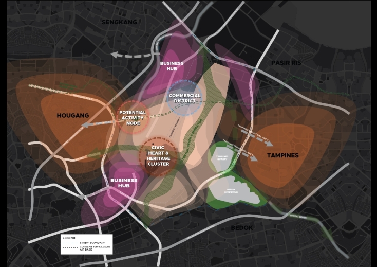
From the 2030s onwards, the Paya Lebar Air Base (PLAB) will make way for a new town in the east of Singapore. It will be redeveloped in phases, starting with Defu, a new-generation neighbourhood next to PLAB. The new town is envisioned to be community-centric and future-ready to cater to evolving needs and lifestyles. More workspaces will also be built for more people to live and work nearby.
Purpose:
with the Paya Lebar Air Base relocation starting from the 2030s,
the large site will be redeveloped into a new mixed-use town — housing,
jobs and amenities — effectively adding sizeable centrally-located land
to the housing/office mix.
URA
Draft Master Plan Planning a new-generation town The redevelopment of PLAB will be guided by the following strategies:
Creating Creating self-sustaining, community-centric neighbourhoods with flexible community spaces. eg urban farming
Stitching Stitching the town together with neighbouring communities, through transport, green and blue networks. eg adult and kid playing in a park
Leveraging Leveraging heritage, such as the old airport structures and a section of the runway, to curate spaces for new social memories.
Reimagining our neighbourhoods To gather ideas and strategies for PLAB’s neighbourhoods, URA invited teams from the National University of Singapore (NUS), the Singapore Institute of Architects (SIA) and the Singapore Institute of Planners (SIP) to develop concepts and visions for the future town.
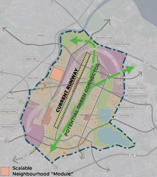
A scalable pedestrian-centric neighbourhood where roads are planned at the borders with a good distribution of homes, jobs and amenities within.
Aerial plan view of a mixed-use urban development with buildings, green spaces, roads, and pedestrian areas. Includes community facilities and residential units.
Conceptual Structure Plan (NUS) The “module” neighbourhood is applied across the masterplan and anchored by two key elements - the repurposed runway and a central linear park. These “modules” are connected to one another via smaller linear parks and waterways that also promotes easy access to amenities within a 5-minute walk.
A pedestrian-centric residential district with amenities ie.Pedestrian streets in commercial area. Self-sustaining and community-centric neighbourhood
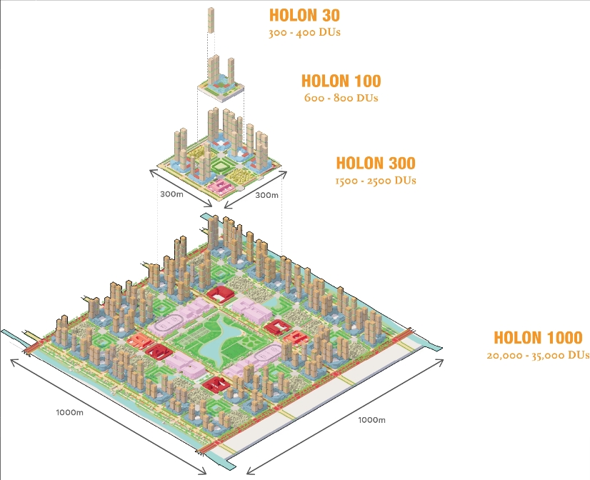
A set of self-sufficient urban modules called “Holons” with jobs and amenities that can function independently or come together to create interconnected neighbourhood in different sizes.
“Holon” units can come together to form large neighbourhoods, each with a sizeable centralised park. This concept looks to retain the runway while distributing greenery more widely across the area through neighbourhood parks.
Map of Sengkang, Hougang, and Bedok showing the current runway and a typical "Holon 1000" area.
Homes and amenities around a neighbourhood park. Pedestrian-friendly street with social and commercial uses. Quality living in a town of tomorrow Seamless multi-modal movement for all Comprehensive walking and cycling networks, the upcoming Cross Island Line and transit priority corridors will enable people of different ages and types of mobility to get around without a car.
City street scene with high-rise buildings, trees, a bus, and people on sidewalks under a blue sky.
Live-work-play-learn-make-rest Spaces can be creatively integrated for different activities in novel combinations. This enables new living patterns that combine homes with various amenities, work and community spaces to create vibrant neighbourhoods.
Flexible and resilient community Multi-functional and adaptable spaces can evolve with changing needs while supporting community interactions and nurturing a sense of belonging. They include flexible spaces that can be adapted to different uses and needs throughout the day.
Harmonious blend of nature and heritage By integrating some elements of the aviation heritage and natural assets into the daily lives of the new community, we recall the past and create spaces for new memories.
Shaping a future-ready neighbourhood in Defu
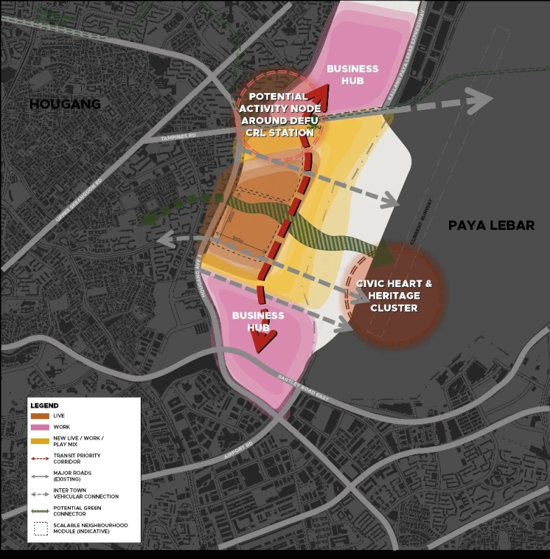
Being immediately next to PLAB, Defu will be redeveloped first as a community-oriented 10-minute neighbourhood. The planned civic heart will encompass some of the former airport buildings that will be adaptively reused to foster social memories of the area’s rich aviation history. Transport, green and blue networks will effectively stitch up the whole neighbourhood.
Map of Hougang and Paya Lebar, Singapore, showing planned business, civic, and residential areas, and transit connections.
Better below Logistics activities such as e-commerce sorting hub can potentially be built underground or integrated within multi-storey carparks (i.e. courier hubs).
|
||||||||||||||||||||||||||||||||||||||||||||||||||||||||||||||||||||||||||||||||||||||||||||||||||||||||||||||||||||||||||||||||||||||||||||||
|
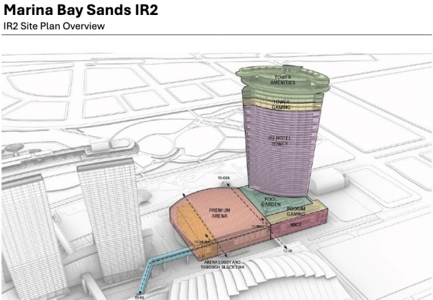
Marina Bay Sands IR2 — The Fourth Tower: Full Design & Attractions Brief
Project:
Marina Bay Sands IR2 (working name; not final)
)
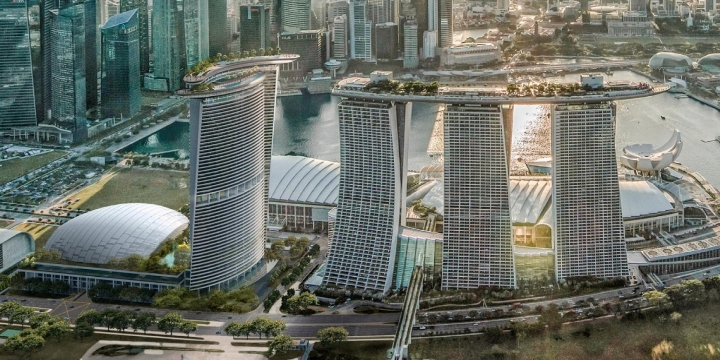
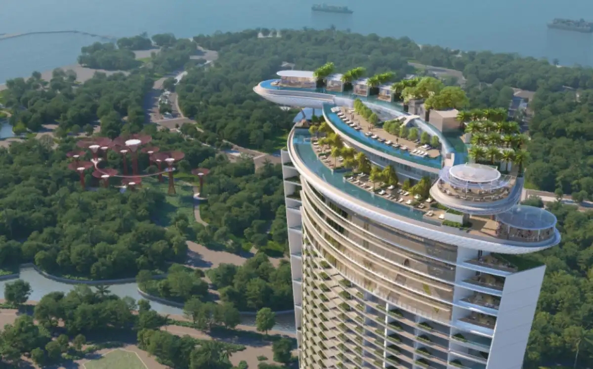
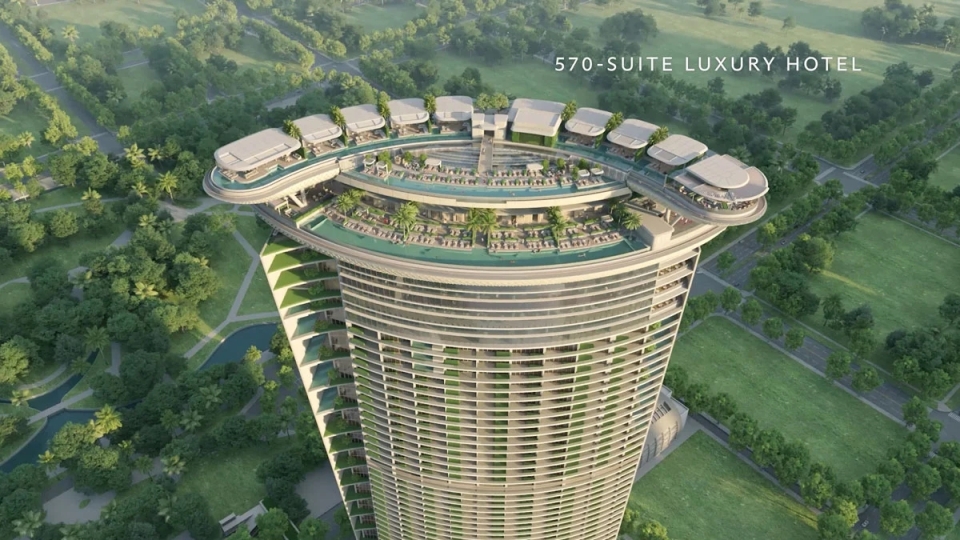
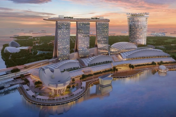
1. Executive Summary Marina Bay Sands is expanding with a fourth tower — an all-suite ultra-luxury hotel and entertainment destination officially dubbed IR2 (a working name, not the final branding). At an estimated US$8 billion (about S$10.3 billion), it is one of the most expensive single hospitality developments in the world, more than doubling the original US$3.3 billion figure announced in 2019. Las Vegas Sands broke ground on 15 July 2025, in a ceremony officiated by Singapore's Prime Minister Lawrence Wong (Marina Bay Sands; Channel NewsAsia). The 55-storey tower is designed by Moshe Safdie — the same architect behind the original 2010 Marina Bay Sands — and is capped by the Skyloop, a 76,000 sq ft multi-level rooftop experience that is the project's signature attraction. A purpose-built 15,000-seat arena designed by Populous (of Las Vegas Sphere and London's O2 Arena fame) sits in the podium beside the tower (Safdie Architects; Marina Bay Sands). 2. Cost & Financing The US$8 Billion Price Tag The US$8 billion cost is more than double the US$3.3 billion originally announced in April 2019. LVS attributed the increase to inflation, the COVID-19 pandemic, and higher labour and material costs (Straits Times). Cost Breakdown (LVS Q3 2024 earnings)
Financing Structure Las Vegas Sands will shoulder 25–35% of the project cost directly, with the remaining 65–75% covered through project financing. By the time IR2 is complete, LVS will have invested more than US$15 billion in Singapore since operations began in 2010 (Straits Times; Marina Bay Sands). For context, the original Marina Bay Sands (opened 2010) cost S$8 billion (US$6.88 billion) and was then the world's most expensive standalone casino property (Wikipedia). 3. The Hotel Tower — Design Considerations
The 45-Degree Rotation The tower is deliberately rotated at a 45-degree angle to the existing three-tower complex. This frames panoramic views of both Marina Bay (toward the city) and out to the Singapore Strait. Safdie noted that the new tower appears interconnected with the originals — "They belong to the same family" — even though it sits on a separate plot (CNN; Safdie Architects). Larger Suites, Fewer of Them The suite count was reduced from the ~1,000 planned in 2019 to 570, because average suite sizes are being made larger than the existing MBS suites (which range 75–600 sq m). LVS President Patrick Dumont said larger suites are necessary to provide "the highest level of luxury service." IR2 also includes 23 "signature multi-bay mansions" for the very top end of the market (Channel NewsAsia; Executive Traveller). No Physical Connection to the Existing SkyPark Safdie briefly considered extending the original boat-shaped skybridge to connect with the new tower, but ultimately decided against it. The Skyloop is instead a "counterpart" to the iconic Sands SkyPark — a distinct new landmark rather than an appendage to the old one (CNN). 4. The Skyloop — Signature Rooftop Attraction The Skyloop is the crowning feature of the new tower — a 76,000 sq ft (≈7,060 sq m) multi-level rooftop experience. Form & Geometry
Lower Skyloop (Public Access)
Upper Skyloop (Hotel Guests Only)
The Skyloop sits at 245 metres above ground — slightly higher than the existing SkyPark — and its two overlapping elliptical decks spiral in opposite directions (Executive Traveller; Safdie Architects).
5. The 15,000-Seat Arena — Special Attraction A purpose-built 15,000-seat arena sits at the core of the podium, designed by global venue firm Populous — responsible for the Sphere in Las Vegas and the O2 Arena in London.
The arena is positioned between the existing property and the fourth tower, with a more open frontage than earlier concepts showed. MBS hopes it will "help attract top entertainers from Asia and around the world" and position the venue as Asia's best live-entertainment destination (Marina Bay Sands; Straits Times). 6. Podium, MICE, Retail, Gaming & Wellness MICE (Meetings, Incentives, Conferences, Exhibitions)
Luxury Retail & Dining
Gaming
Wellness
(Channel NewsAsia; Marina Bay Sands; Executive Traveller) 7. Sustainability & Biophilic Design Sustainability is a core design driver, aligned with MBS's global Sands ECO360 strategy. Biophilic Design
Energy & Thermal Comfort
Materials & Waste
8. Connectivity & Urban Integration The development is integrated with both new and existing elements of the Marina Bay precinct:
Notably, despite its prominence, the arena will be integrated with surrounding developments for seamless pedestrian movement, rather than standing as an isolated object (Safdie Architects; Marina Bay Sands). 9. Timeline
Note: An earlier April 2024 estimate had cited July 2029 completion; the current official figure is June 2030 with a January 2031 opening. (Channel NewsAsia; Straits Times; Straits Times) 10. Design Considerations — Summary
11. Key Watch-Items & Open Questions
12. Sources
|
||||||||||||||||||||||||||||||||||||||||||||||||||||||||||||||||||||||||||||||||||||||||||||||||||||||||||||||||||||||||||||||||||||||||||||||
|
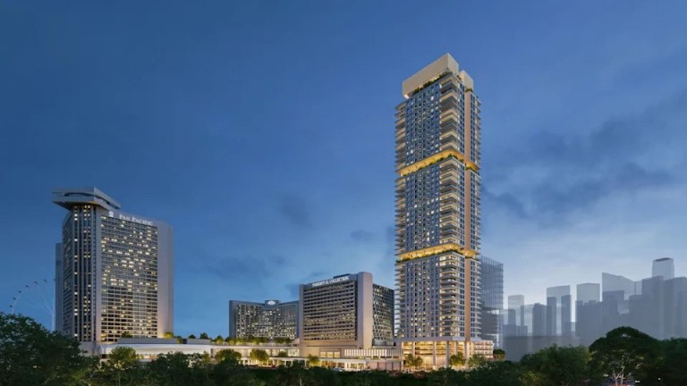
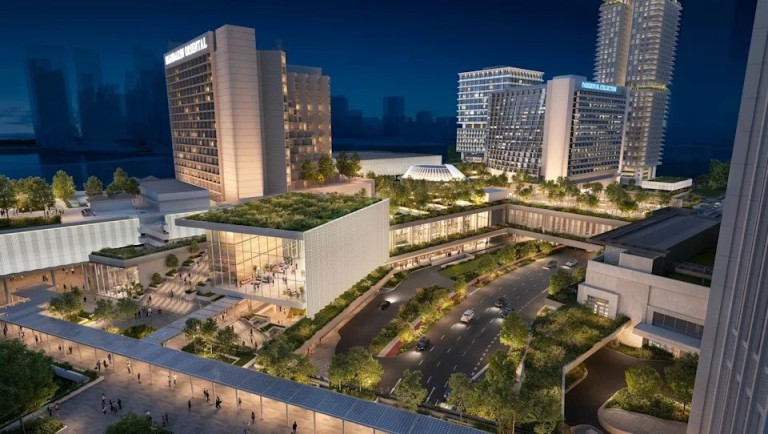
MARINA SQUARE REDEVELOPMENT Here's the comprehensive master plan brief for the Marina Square redevelopment, verified against primary sources (PLP Architecture, SingLand/UOL, Straits Times, Business Times). Key verified findings All your specified facts check out against the 1 September 2026 announcement:
Two things worth flagging
The full brief (12 sections covering site context, tower-by-tower programme, hotel integration, the adaptive-reuse retail podium, the Botanical Loop and 6,500 sq m public park, sustainability, phasing, and risks) is in the shared document. Marina Square Redevelopment — Master Plan Brief
Project:
Partial redevelopment of the Marina Square complex
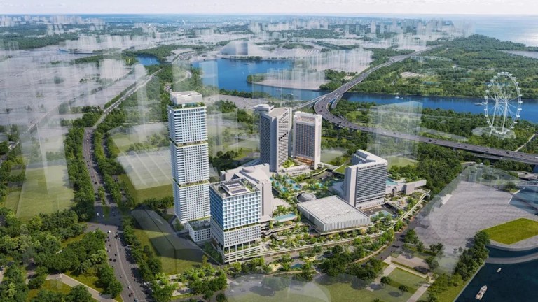
1. Executive Summary Singapore Land Group (SingLand), together with its parent UOL Group, will partially redevelop the 1980s-era Marina Square complex into what it calls "Singapore's first hyper-mixed development" — a unified, outward-looking live-work-play precinct on 9.2 hectares of reclaimed land in the Core Central Region (RE Talk Asia). The redevelopment introduces three new towers around a retained and enhanced retail podium, while all three existing hotels remain fully operational throughout construction. The site's overall gross floor area (GFA) will expand to about 362,493 sq m (360,000+ sq m), with the Marina Square shopping mall closing on 31 March 2027 for roughly four years of works and the overall project targeted for completion by 2031 (Business Times; Straits Times). London-based PLP Architecture is precinct masterplanner and lead designer, working alongside local architect DP Architects, with a design narrative that reinterprets the legacy of the original architect, American John Portman, who pioneered the atrium-hotel typology (PLP Architecture). 2. Site & Strategic Context
The SDI scheme is the planning vehicle enabling the GFA uplift. It encourages the rejuvenation of older buildings in strategic areas and the delivery of transformational public benefit (RE Talk Asia; Business Times). As part of advancing the scheme, SingLand's indirect subsidiary Marina Residential Development signed four agreements (3 December 2025) to acquire a 3,992 sq m land parcel at 6 Raffles Boulevard for S$99.1 million from Marina Centre Holdings, Hotel Marina City, Aquamarina Hotel and Marina Bay Hotel (Straits Times). The surrounding context has transformed dramatically since Marina Square was built — the Esplanade, Marina Bay Sands, and Gardens by the Bay have emerged around it, while Marina Square itself remained largely unchanged for four decades. The redevelopment is framed as reintegrating the introverted precinct into this wider civic landscape (RE Talk Asia). 3. The Three New Towers The partial redevelopment adds three new buildings across the 9.2-hectare site. Together they expand the site to ~362,493 sq m GFA and reinforce a 24/7 live-work-play character (Business Times; PLP Architecture).
Tower 1 — 49-Storey Residential Tower The 190 m-tall, 49-storey residential tower is the development's landmark building, housing 204 large-format luxury homes ranging from three- to five-bedroom apartments to penthouses (The Edge Singapore; Stacked Homes). The units are positioned for sale, capitalising on the recently approved GFA uplift under the SDI scheme (Stacked Homes). Tower 2 — 19-Storey Mixed-Use Block (Hotel & Office) The 19-storey mixed-use block combines a 304-key hotel (floors 4–10) with about 13,000 sq m of Grade A lettable office space (floors 12–19), set within a folded facade and incorporating shared spaces for networking, events and social interaction (Stacked Homes). The hotel operator has not yet been appointed (MissLobang). Tower 3 — 24-Storey Serviced Apartment Block A 24-storey serviced apartment block provides 260 keys for longer-stay guests, with panoramic views towards Marina Bay and Bay East Garden (Stacked Homes). The serviced apartment operator has not yet been appointed (MissLobang). 4. Integration with Existing Hotels A defining principle of the masterplan is the retention and integration of all three existing hotels, which remain fully operational throughout the redevelopment works (RE Talk Asia; Straits Times).
These three hotels are among the works still standing in Singapore by John Portman, the American architect who pioneered the atrium-hotel typology. PLP's masterplan reinterprets Portman's originally inward-facing urbanism as a unified, outward-facing composition that reintegrates the hotels with the new towers, the enhanced mall, and the public realm (RE Talk Asia).
The new 304-key hotel
and 260-key serviced apartment block bolster (rather than
replace) the existing hotel offerings, adding a new hotel and a
serviced-apartment component alongside the three existing hotels to
serve both transient and longer-stay guests (Stacked
Homes). 5. Retail Podium — Adaptive Reuse of the Mall The existing four-storey Marina Square Shopping Mall (more than 76,000 sq m of retail/mall GFA; roughly 800,000 sq ft of net lettable area) will undergo a major enhancement rather than demolition. Its structure is retained to save embodied carbon, with new construction within the mall limited to small zones necessary for future-proofing (RE Talk Asia; MissLobang). The mall will be completely repositioned as a central platform linking the hotels, new offices, residences, serviced apartments and public spaces, with a broader variety of food and beverage (F&B) options and pet-friendly environments (Straits Times; Business Times). 6. Public Realm, Gardens & Connectivity Botanical Loop & Urban Garden PLP's masterplan incorporates an elevated Botanical Loop running around a sequence of gardens, connecting to six new nodal points featuring terraces, a mall, a concourse, an oculus, and vertical circulation points across multiple levels. The loop sits within a new large-scale, multi-level urban garden that reimagines retail experiences and public spaces (RE Talk Asia; PLP Architecture). Public Park over Stamford Canal A proposed 6,500 sq m public park with greenery, playscapes and event spaces will be created along Raffles Avenue over Stamford Canal, providing a new green frontage for the precinct (Straits Times). Pedestrian Connectivity A new continuous sheltered walkway and the elevated Botanical Loop will strengthen pedestrian links to:
Placemaking Strategy Movement is conceived as placemaking rather than mere circulation, guiding visitors through a varied landscape of arrival, activity and transition. The plan creates a continuous network incorporating public realm, landscape, retail, wellness, sport amenities, hotel arrivals and pedestrian connections, anchored by a new integrated podium that improves pedestrian flows at both ground and elevated levels and strengthens links to transport infrastructure (RE Talk Asia). 7. Design Team & Architectural Narrative Design Team
PLP Architecture is an award-winning studio with a portfolio including Bankside Yards (described as the UK's first fossil-free, net-zero mixed-use development), Parco Romana in Milan, and Tokyo Cross Park. In Singapore, PLP created Park Nova along Orchard Boulevard and is currently working on SingLand's redevelopment of Clifford Centre at Raffles Place (rebranded The Clifford) (RE Talk Asia). PLP's Singapore studio was established in 2023 by Partner Tina Qiu, who leads the firm's Southeast Asia and China operations. PLP President Lee Polisano leads the project vision (RE Talk Asia). Architectural Narrative John Portman's original Marina Square design was "tropical modernist" — strong geometric forms, interconnected podium levels, large internal atrium spaces, and an "interior urbanism" that emphasised placemaking within buildings. Portman pioneered the atrium hotel typology, and his Marina Square model was remarkably forward-looking for its time but introverted and unconnected with its surroundings.
PLP's design
objective is to understand why Portman's vision succeeded, reinterpret
its original energy and excitement, protect the Portman legacy
sensitively, and transform the precinct into a public-facing, connected
piece of civic urbanism. Each new building will have distinct
architecture and character, harmonising with the climate and context (RE
Talk Asia). 8. Sustainability & Decarbonisation The redevelopment's stated carbon-reduction approach includes:
Note: PLP has not publicly stated a quantified carbon-reduction target, energy-performance target, green-building certification, or net-zero completion date for the project. 9. Construction Timeline & Phasing (2027–2031)
The existing three hotels remain open throughout the construction period (Straits Times; Business Times). 10. Programme Summary — New vs. Existing
11. Key Risks, Open Questions & Watch Items
12. Sources
Prepared as a master plan brief. Figures are drawn from developer and architect announcements dated September 2026 and earlier Singapore press coverage; the project remains in detailed design, so quantitative specifications should be treated as indicative pending final approval and construction documentation. Structure
Each slide includes
Two things built in for you
The file is shared
above. If you'd like, I can turn this outline into an actual PowerPoint
deck with the PLP masterplan visuals, or tighten it to a 10-minute
lightning version. +++++++++++++++++++++ Marina Square Redevelopment — Presentation Outline with Speaker Notes
Format:
Slide-by-slide outline. Each slide lists on-slide bullet points followed
by speaker notes for live delivery. Slide 1 — Title On-slide:
Speaker notes: Slide 2 — Why This Matters On-slide:
Speaker notes: Slide 3 — Project Snapshot On-slide:
Speaker notes: Slide 4 — Planning & Approval Pathway On-slide:
Speaker notes: Slide 5 — The Three New Towers: Overview On-slide:
Speaker notes: Slide 6 — Tower 1: 49-Storey Residential Tower On-slide:
Speaker notes: Slide 7 — Tower 2: 19-Storey Mixed-Use Block On-slide:
Speaker notes: Slide 8 — Tower 3: 24-Storey Serviced Apartment Block On-slide:
Speaker notes: Slide 9 — Integration with Existing Hotels On-slide:
Speaker notes: Slide 10 — Retail Podium: Adaptive Reuse of the Mall On-slide:
Speaker notes: Slide 11 — Public Realm & Connectivity On-slide:
Speaker notes: Slide 12 — Design Narrative: Reinterpreting Portman On-slide:
Speaker notes: Slide 13 — Sustainability & Decarbonisation On-slide:
Speaker notes: Slide 14 — Timeline & Phasing On-slide:
Speaker notes: Slide 15 — Risks & Open Items On-slide:
Speaker notes: Slide 16 — Key Takeaways On-slide:
Speaker notes: Delivery Notes
PLP Architecture retaining Marina Square's mall structure, adding three new towers Jovi Ho Tue, 1 September 2026 at 9:00 am SGT The precinct masterplanner and lead designer says a 204-unit luxury residential tower will be the development's tallest. The firm is also currently working on the redevelopment of Clifford Centre. London-based PLP Architecture has been appointed precinct masterplanner and lead designer, alongside local architect DP Architects, for the transformation of the 1980s-era Marina Square complex into what Singapore Land Group (SingLand) calls "Singapore's first hyper-mixed development". Over four years starting March 31, 2027, SingLand will redevelop the Marina Square complex, which also includes the three adjacent hotels Pan Pacific Singapore, Parkroyal Collection Marina Bay and Mandarin Oriental Singapore. These three existing hotels will remain operational throughout the redevelopment works. SingLand will introduce three new buildings to the site: a 19-storey mixed-use block comprising a 304-key hotel and 13,000 sqm of lettable office space, a 49-storey residential tower with 204 units of three- to five-bedroom apartments and penthouses, and a 260-key serviced apartment block. The 190m-tall, 49-storey residential tower will be the development's landmark building. As the tallest structure within the new project, its design is a "metropolitan response" to the relationship of Marina Square within Marina Bay, says PLP Architecture partner Tina Qiu, who set up the firm's Singapore studio in 2023 and leads the practice's Southeast Asia and China operations. In Singapore, PLP created Park Nova, the ultra-luxury residential development along Orchard Boulevard unveiled by Hong Kong's Shun Tak Holdings in 2021. The firm is also currently working on SingLand's redevelopment of Clifford Centre, which has been rebranded to The Clifford. Commenting on the news, ERA Singapore CEO Marcus Chu says the redevelopment "is expected to inject fresh vibrancy into the Marina Square area". "With its mix of residential, hospitality, retail, office and public spaces, the project will strengthen the area's appeal as a live-work-play destination and support activity throughout the day." Given the limited residential supply in the immediate vicinity, the future luxury condominium is "likely to attract buyers who value city-centre living, connectivity and convenient access to retail, dining, hospitality and business amenities", he tells City & Country. Cutting embodied carbon SingLand received a grant of written permission under the Urban Redevelopment Authority's Strategic Development Incentive (SDI) scheme on Aug 31, which encourages the rejuvenation of older buildings in strategic areas into bold, innovative developments that transform the precinct. Responding to City & Country, a JustCo spokesperson says the company was only informed of SingLand's plans to close Marina Square shopping mall for redevelopment on Sept 1. Co-working operator JustCo is identifying relocation options for its Marina Square members as the shopping mall is set to close on March 31, 2027 for redevelopment works. Responding to City & Country, a JustCo spokesperson says the company was only informed of SingLand's plans to close Marina Square shopping mall for redevelopment on Sept 1, when Singapore Land Group (SingLand) unveiled its plans to partially redevelop the Marina Square complex, which includes the mall and three adjacent hotels. JustCo operates a 57,000 sq ft space on the mall's third storey. The spokesperson says JustCo's "immediate focus" is to help its members move to its "growing Singapore network of over 20 locations". "Singapore remains a core market for JustCo," the spokesperson adds. "In January, we opened The Collective Labrador Tower and most recently announced new centres at The Octagon at Cecil Street and JustCo Place along Orchard Road." JustCo, which listed on the Mainboard of the Singapore Exchange in May, "continues to have a pipeline in Singapore", and the company will announce new openings and share information via bourse filings. SingLand announced on Sept 1 the partial redevelopment of Marina Square complex into "Singapore's first hyper-mixed development" by introducing three new buildings: a 49-storey 204-unit luxury residential tower with three- to five-bedroom apartments, a 19-storey mixed-use block with a 304-key hotel from the fourth to 10th floors and a Grade-A office component covering some 140,000 sq ft from the 12th to 19th floors, and a 24-storey 260-key serviced apartment. To facilitate the redevelopment, SingLand will close the mall for construction works on March 31, 2027. Opened in 1986, Marina Square shopping mall is a five-storey retail mall with a net lettable area of 0.8 million sq ft. It last underwent major renovation works about a decade ago. Marina Square shopping mall is valued at $1.05 billion, unchanged since June 30, 2023. Last month, it was reported that two major tenants will leave Marina Square for SingPost Centre in Paya Lebar. DP Architects, which occupies about 45,000 sq ft, and PSB Academy, which occupies a total of about 136,000 sq ft, are said to exit Marina Square in 1H2027. At JustCo's 1HFY2026 results briefing on Aug 7, CEO Kong Wan Sing said the company had yet to receive a "formal notice" from its landlord at Marina Square. He added that any transition would likely come with "ample" lead time of nine to 12 months. He also highlighted JustCo's newest location at 160 Orchard Road, also known as Orchard Point. Under a master lease with OG, JustCo Place will comprise 40 retail units from the basement to the second floor of Orchard Point, a 64,000 sq ft premium JustCo co-working space on levels three and four, and 123 serviced apartment units spanning about 100,000 sq ft under the new JustAt brand from levels six to 10. JustCo Place is scheduled to open this month with Deloitte as its anchor lessee. Deloitte will take up 100% of the co-working space.
|
||||||||||||||||||||||||||||||||||||||||||||||||||||||||||||||||||||||||||||||||||||||||||||||||||||||||||||||||||||||||||||||||||||||||||||||
|
Greater Sentosa Master Plan (GSMP) is the major ongoing transformation of Sentosa Island (and the neighbouring island of Pulau Brani). Unveiled in its latest detailed chapter on 3 July 2026 by the Sentosa Development Corporation (SDC), it is a long-term, phased plan spanning roughly two decades (with first major openings from the early 2030s and overall completion targeted around 2045). The goal is to turn the combined area into Singapore’s enhanced “island playground and sanctuary,” roughly doubling annual visitors from about 16–17 million (2024/25 figures) to around 32 million. It integrates Sentosa with the ~120-hectare Pulau Brani (whose port operations are set to phase out by around 2027), unlocking space for new attractions, hotels, experiences, and better connectivity while emphasising nature, sustainability, coastal protection, and local identity. Key New Landmarks & Experiences on Sentosa
Sentosa Cove residential area and the two golf courses (Serapong and Tanjong) are expected to remain largely untouched. Developments at Pulau Brani & Connectivity
Theme Parks / Resorts World Sentosa (RWS) ExpansionsResorts World Sentosa (home to Universal Studios Singapore) is undergoing a major multi-billion-dollar expansion (often referred to as RWS 2.0 / waterfront lifestyle development), targeted for completion around 2030:
Other Notes
These developments are still largely in the planning and early implementation stages, with artist impressions released and progressive openings expected from the early 2030s onward. Official details continue to be refined by SDC and partners. For the latest visuals and updates, check the Sentosa Development Corporation website or recent government announcements. +++++++++++++++++++++ BODHI Spa → Premium luxury day spa with high-tech wellness treatments (already open at Sentosa) BODHI Spa (Australian)
Key attractions & offerings:
This is a more traditional luxury day spa experience focused on holistic restoration.
|
||||||||||||||||||||||||||||||||||||||||||||||||||||||||||||||||||||||||||||||||||||||||||||||||||||||||||||||||||||||||||||||||||||||||||||||
|
Cross Island Line (CRL) — east-west strategic rail backbone This is part of the Singapore MRT story.
Purpose:
a long cross-island MRT line to improve orbital rail connectivity
(linking western & eastern corridors without routing through the central
core), cut travel times and support new developments along the corridor.
Land
Transport Authority The Singapore MRT story Here’s a clear comparison of when each Singapore MRT line started operations (first passenger service date). Chronological Order of First Opening
Quick Summary by Age (as of August 2026)
Upcoming Lines (for context)
Notes:
Would you like the staged opening dates for any specific line in more detail?
Cross Island Line (CRL)
is Singapore’s eighth MRT line and will be its longest fully underground
line when complete. Completion Timeline It is being built in phases:
Full line (including a future link toward Changi Airport Terminal 5): Expected to span ~65–67 km with 26–27 stations (11 interchanges) when complete in the late 2030s. It will run from the Changi/T5 area in the east across the island to Gul Circle in the west, serving residential, industrial, and growth areas such as Punggol Digital District and Jurong Lake District. Expected initial daily ridership is at least 600,000, rising toward 1 million longer-term. Total Singapore MRT Network As of mid-2026 (after Circle Line Stage 6 opened on 12 July 2026, completing the loop):
The network is expanding further (Jurong Region Line from mid-2028, more TEL/DTL extensions, etc.), with plans to reach ~360 km by the early 2030s.
Comparison of Operating MRT Lines (Approximate Figures as of mid-2026) Figures are drawn from consistent sources such as SGTrains and Wikipedia updates (lengths and station counts can have minor variations depending on whether branches or unique stations are emphasised). Interchange stations are typically counted toward each line they serve.
Key points:
Upcoming / under construction (for context, not yet operating):
These figures can shift slightly with new openings or official updates. For the absolute latest maps, station details, or construction progress, check the Land Transport Authority (LTA) website. |
||||||||||||||||||||||||||||||||||||||||||||||||||||||||||||||||||||||||||||||||||||||||||||||||||||||||||||||||||||||||||||||||||||||||||||||
|
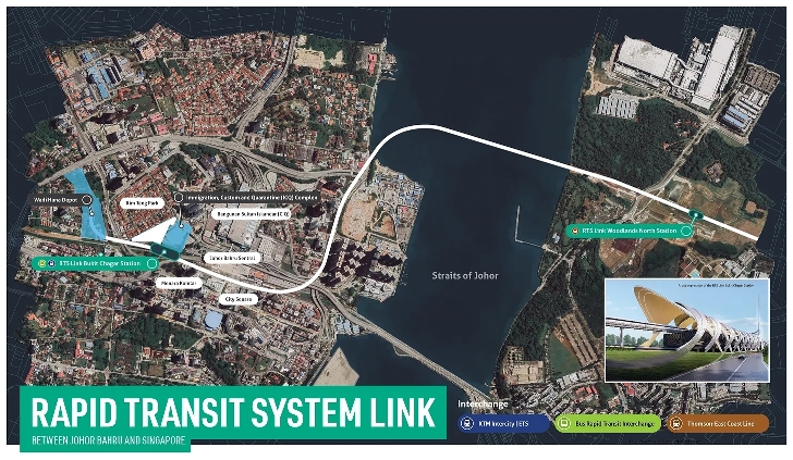
RTS – Johor RTS (Johor Bahru — Singapore Rapid Transit System) — cross-border connectivity
Purpose:
a short, high-capacity cross-border rail link connecting Woodlands North
(Singapore) and Bukit Chagar (JB) to replace part of the existing
shuttle and reduce road congestion across the Causeway; it's designed
for seamless pre-clearance CIQ at stations.
Land
Transport Authority+1
Purpose: a new integrated district to host digital/tech companies, cybersecurity firms, start-ups and research Johor Bahru–Singapore Rapid Transit System (RTS Link) is a dedicated cross-border rail shuttle between Singapore and Johor Bahru, Malaysia. It is designed to ease congestion on the Causeway (one of the world’s busiest land borders) by providing a fast, reliable alternative for daily commuters and travellers. Latest Update (as of August 2026)
System Overview
Immigration System (Key Feature) The RTS uses a co-located Customs, Immigration and Quarantine (CIQ) arrangement — a major improvement over traditional border crossings:
Passenger Capacity
This capacity is intended to take a substantial share of current Causeway traffic (estimated at 30–40% in some projections). Timeline Summary
The RTS Link is expected to replace the existing KTM Shuttle Tebrau service within about six months of opening. In short: The RTS Link will offer a fast (~5-minute), high-capacity, driverless rail connection with convenient co-located immigration clearance, aiming to transform daily cross-border travel between Singapore and Johor Bahru starting in late 2026 or early 2027.
5 minutes to Singapore?
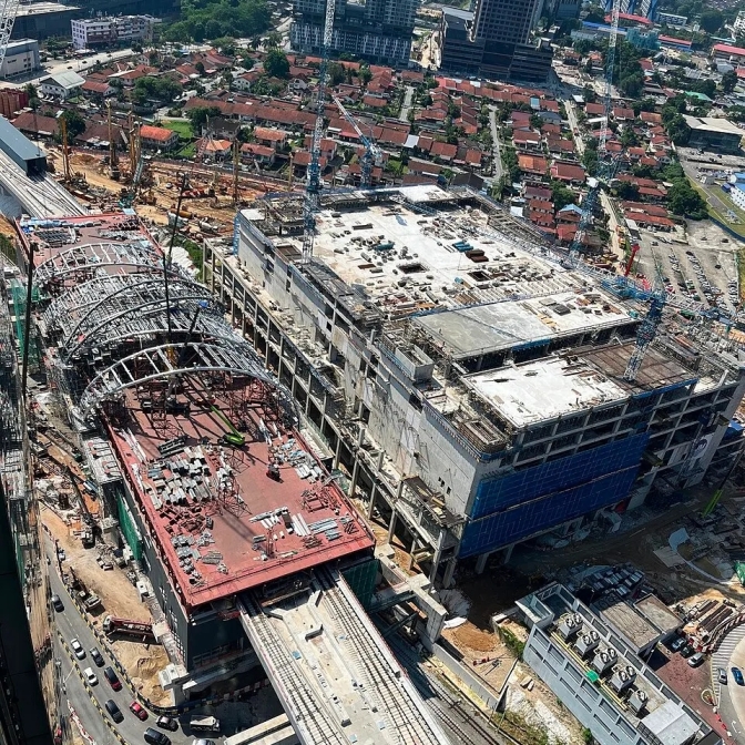
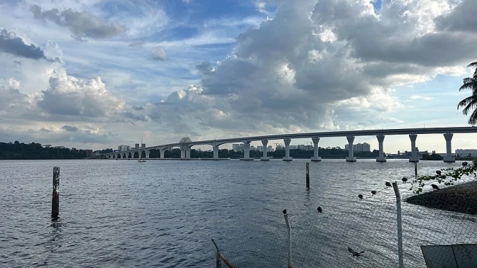
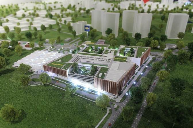
Inside the RTS Link transforming the Johor Strait The rapid transit link connects the neighboring nations with painless daily commutes, a major step toward green transit, and a lingering question over system capacity THE SOUTHEAST ASIA DESK, Marianne Ayko, and Alvin Qobulsyah Jul 15, 2026 RTS LINK - MRT Corp The Main Takeaway The long-held dream of seamless rail connectivity across the Tebrau Strait is on the verge of coming true. The Rapid Transit System (RTS) Link will connect Bukit Chagar in Johor Bahru with Woodlands North in Singapore. Construction of the Johor Bahru–Singapore RTS Link has officially completion milestone, and civil works have advanced to high-speed testing with flawless train trials scheduled before its highly anticipated commercial launch. Once in operation, this 4 km light rail network will be able to carry up to 10,000 passengers per hour in each direction. The crossing is only five minutes long and relieves the pressure on the Johor–Singapore Causeway, formerly known as the world’s busiest international land border crossing. Why It’s on Our Radar A historic and geopolitical deal: The smooth integration of the economies of Singapore and Johor was constrained by decades of physical tension at the border. RTS Link is the most concrete and high-stakes infrastructure bridge between the two nations today. A relief for daily commuters: The Johor-Singapore Causeway usually traps commuters in exhausting 2 to 4-hour traffic blockages. Beyond being an update on public transit, this rail link is an economic lifeline for thousands of cross-border workers, taking 35% of peak-hour vehicle congestion off the road. Accelerator for JS-SEZ: The success of the proposed Johor-Singapore Special Economic Zone (JS-SEZ) depends entirely on the free movement of people. The RTS Link is the physical engine that drives this massive area, shaping how skilled workers, retail spending, and corporate expansion operate across the strait. With the 2026 Final Completion- and as this shift takes hold, the economic change in consumer patterns and property markets and transit networks is under close review. The Construction Journey: The road to the 2026 final stretch has been a complex engineering and political challenge, marked by delays, scope revisions, and significant bilateral momentum. The early roadblocks (2018-2020): The project was first announced in 2010, but was delayed and revised several times due to changes in political administrations and financial overruns on both sides. In 2020, it was restructured from a heavy Mass Rapid Transit (MRT) model to a new Light Rail Transit (LRT) system. The maintenance base was moved from Mandai (Singapore) to Wadi Hana (Johor Bahru), stabilizing the project cost at approximately RM3.7 billion. The Sea Crossing Breakthrough (2023–2024): The biggest engineering challenge was solved when teams built a 17.1-meter strong concrete bridge over the water that connected Malaysia’s Pier 47 to Singapore’s Pier 48. It hangs 26 meters above the Straits of Johor and connects Bukit Chagar in Johor Bahru with Woodlands North in Singapore Systems & Track, Trials: The trains are manufactured by the China Railway Rolling Stock Corporation (CRRC), which produces high-capacity trains capable of carrying over 600 passengers each. With a peak frequency of a train every 3.6 minutes, high-speed integration testing at the Singapore Rail Test Center (SRTC) has proven that the automated signaling systems are ready for prime time. The Wins Although the RTS Link is widely celebrated as a regional triumph, its success relies on balancing a set of pros and cons. On the winning side, the system’s most significant operational breakthrough is its co-located Customs, Immigration, and Quarantine (CIQ) layout. By allowing commuters to clear both Malaysian and Singaporean border checks at their departure point, the project removes the secondary queues that have long plagued cross-border travel. Once the train arrives, passengers can simply step off the platform and walk straight out into the city. By carrying up to 10,000 travelers per hour, this electric shuttle will eliminate tens of thousands of cars and motorcycles from the road each day, helping lower the border’s carbon footprint and making commutes from hours to just 5 minutes. This massive change in accessibility is already helping the local economy, fueling a real estate boom in Johor Bahru, where property values around the Bukit Chagar station are climbing rapidly due to strong demand from local buyers and Singaporean investors seeking lower living costs. The Remaining Challenges However, concerns surrounding the system’s actual infrastructure could easily shift the traffic from the bridge to the platform. The biggest worry is the threat of platform overcrowding: a five-minute train ride won’t mean much if connecting lines, like Singapore’s Thomson-East Coast Line, or local feeder buses can’t clear the peak-hour crowds fast enough. Fares are another issue. If ticket prices are scaled too heavily toward the stronger Singapore Dollar to recover building costs, the line risks pricing out the very Malaysian workers who need it most, pushing them right back onto the Causeway on their motorcycles. There is also doubt about the project’s scale. Choosing a lighter, cheaper LRT system instead of a heavy rail system means the network might reach its capacity long before the region’s economic growth slows. The Economic Impact The RTS acts as the structural foundation for the upcoming Johor-Singapore Special Economic Zone (JS-SEZ). During recent high-level diplomatic meetings, both countries welcomed strong progress and stated they expect the master plan to be finalized in the near future to accelerate trade, investment, and cross-border economic integration. Singapore President Tharman Shanmugaratnam pointed to the JS-SEZ and the RTS Link as two flagship initiatives demonstrating the shared ambition to deepen economic integration. The infrastructure is scaling up significantly on both sides to catch the incoming human wave:
Singapore's Woodlands Gateway: Plans have been unveiled for a transport hub in Woodlands, linked directly to the Johor Bahru-Singapore Rapid Transit System and the Woodlands North MRT station. According to JTC Corporation tender details, the mixed-use transport hub sits on a 5.66-hectare site and will feature a network of underground roads to take heavy vehicles and trucks directly to industrial offices, keeping the ground level free of heavy traffic. Johor's Bukit Chagar Transformation: In Malaysia, it was announced that the four-floor station building will be built within a massive development that includes a transport hub, apartments, and shops. Environmental Impact The environmental stakes of the RTS are crucial. Currently, thousands of vehicles wait on the Causeway for hours every single day, creating a severe localized air pollution corridor over the Tebrau Strait. By shifting commuters to an all-electric rail system, the RTS acts as a massive environmental shield. Pulling private vehicles off the road in favor of high-frequency electric trains will lower carbon emissions along the border, aligning both Singapore and Malaysia with their regional sustainability commitments. The Bottom Line No longer just a political talking point, the Singapore-Johor RTS Link is practically a finished deal, reshaping the regional landscape. Once operations begin, this train line will do much more than move people—it will tie the economic fortunes of both nations together for the next generation. The RTS Link is the primary near-term catalyst for Johor Bahru (JB) property values, but its impact is highly localised rather than a broad market-wide boom. The Johor Bahru–Singapore Rapid Transit System (RTS) Link is a short cross-border rail shuttle connecting Bukit Chagar station in JB to Woodlands North in Singapore. Targeted for passenger operations around end-2026 / early 2027 (station structure largely complete by mid-2026), it will cut the journey to roughly 5–6 minutes, with design capacity of about 10,000 passengers per hour per direction and co-located CIQ facilities. Observed Price Impact to Date (2024–mid-2026)
This is consistent with historical transit effects in Malaysia. Studies of the Sungai Buloh–Kajang MRT line found a roughly 9.5% premium for condos within ~400 m of an operational station versus comparable properties further away. The RTS premium has been materialising during construction (as visibility and confidence grew) and is expected to firm further closer to, and after, opening. Spatial Gradient of Impact The effect decays quickly with distance:
Rental Market Effects Rental demand has strengthened in the RTS corridor, particularly for compact, well-managed units suitable for daily Singapore-based workers (Malaysians earning SGD or Singaporeans seeking lower costs). Gross yields in the immediate catchment are reported higher than the broader JB average (often cited in the 4.5–9% range depending on the source and unit type, versus typical low-to-mid single digits city-wide). Vacancy periods have shortened for desirable stock. Supporting and Offsetting Factors Positive drivers:
Key risks and constraints:
Outlook The RTS is genuinely re-rating the immediate Bukit Chagar–JB Sentral catchment, turning it into a more viable satellite living option for Singapore-linked workers and creating a durable location premium. Properties with genuine walking distance, freehold tenure, good management, and suitable unit sizes (compact dual-key or 1–2 bedroom layouts) are best positioned. Broader JB benefits indirectly through improved overall connectivity and sentiment, but gains are selective. Historical transit precedents and current transaction patterns suggest the strongest residual upside is concentrated within roughly 1–2 km of the station, with the full effect becoming clearer once daily ridership is established in 2027 and beyond. Location relative to the station now matters more than the generic “JB” label. Always cross-check the latest transaction data (NAPIC, Brickz, EdgeProp) and project-specific fundamentals, as the market remains two-speed. The Johor-Singapore Special Economic Zone (JS-SEZ) is a bilateral initiative formalised by an agreement signed on 6–7 January 2025 between the governments of Malaysia and Singapore. It aims to create an integrated cross-border economic hub that combines Singapore’s strengths in finance, technology, talent, and connectivity with Johor’s larger land area, lower costs, and industrial capacity. Key Facts
Facilitating measures include the upcoming RTS Link (end-2026/early 2027), passport-free QR clearance at land checkpoints, streamlined customs (single transshipment permit), and a one-stop investment facilitation centre. The Nine Flagship Zones The zone is organised around nine industry-focused flagship areas (sometimes labelled A–I). Incentives are not uniform—seven zones (A–G) fall under the main JS-SEZ tax package, while Pengerang and Forest City have tailored arrangements.
Key Tax and Other Incentives Applications are open from 1 January 2025 to 31 December 2034 via MIDA. Main highlights include:
Eligibility is activity- and location-specific (operations must be in the relevant flagship zone and meet sector criteria). Detailed guidelines are available from MIDA. Current Status and Outlook Investor interest remains robust (hundreds of enquiries, significant realised investments). Supporting infrastructure (RTS, improved border processes, industrial parks, data centres) is advancing. Challenges include coordination between federal and state levels, timely rollout of the full master plan, and ensuring job creation and infrastructure keep pace with investment. The zone is designed as a “twinning” model—companies can leverage complementary operations across the border rather than a fully unified jurisdiction. For the latest official details, refer to MIDA (mida.gov.my), EDB Singapore, IRDA/Invest Johor, or the IMFC-J facilitation centre, as guidelines and project lists continue to evolve.
|
||||||||||||||||||||||||||||||||||||||||||||||||||||||||||||||||||||||||||||||||||||||||||||||||||||||||||||||||||||||||||||||||||||||||||||||
|
Punggol Digital District — tech & education cluster (digital, cybersecurity, smart-city testing)
Purpose:
a new integrated district to host digital/tech companies, cybersecurity
firms, start-ups and research — anchored by JTC/NTU/other institutions
to create a live-work-learn innovation cluster. It’s also a showcase for
smart-district technologies.
JTC+1
|
||||||||||||||||||||||||||||||||||||||||||||||||||||||||||||||||||||||||||||||||||||||||||||||||||||||||||||||||||||||||||||||||||||||||||||||
|
N parks and Sustainability Journey NParks / “City in Nature” This is part of our sustainability story This can make a very good presentation for visitors to Singapore, especially if you want to explain that Singapore's sustainability story is not simply about planting trees—it is about how a highly urbanised city deliberately integrates nature, water, transport, buildings, biodiversity and community into city planning. I would structure your presentation around one central story: “Singapore: From a Garden City to a City in Nature — how sustainability became part of the way we plan and build a city.” The Singapore Green Plan 2030 is the national framework, launched in 2021, with five pillars: City in Nature, Energy Reset, Sustainable Living, Green Economy and Resilient Future. Suggested presentation structure 1. Singapore's sustainability challenge
This creates the interesting question: How do you build a modern city without destroying the environment that makes the city liveable? 2. The Singapore story begins with “Garden City” The story goes back to 1963, when Singapore's nationwide tree-planting campaign began. The objective was initially quite practical:
The strategy evolved from simply “greening” the city to creating a biophilic urban environment, where greenery and nature become part of the infrastructure of the city. This gives you a nice historical progression:
1960s — Clean & Green
Singapore 3. What changed with “City in Nature”? This is probably the most important part of your presentation. You can explain:
Garden City was about
bringing greenery into the city. That is a much more sophisticated idea. The objective is not simply to plant ornamental trees. It is to:
NParks describes the City in Nature strategy through five key strategies. 4. The five NParks strategies 🌳 1. Grow Nature Park Networks Singapore has four nature reserves, which are important reservoirs of biodiversity and ecosystem services. Nature parks around them act as buffers and help protect the reserves from surrounding urban development. Singapore currently identifies 20 nature areas. A very good example for tourists is the Central Nature Park Network, connecting areas around Bukit Timah and the Central Catchment. 🌿 2. Naturalise Gardens and Parks This is where you can explain the difference between an old-fashioned manicured park and a more ecological park. Instead of: grass + ornamental plants + concrete Singapore increasingly uses: native plants + natural habitats + biodiversity + wetlands + forest structure NParks' current targets include restoring ecological habitats in at least 50% of gardens and parks, together with restoration of forest, marine and coastal habitats. 🏙️ 3. Restore Nature into the Urban Landscape This is a fascinating concept for visitors. Nature is not restricted to parks. It is being integrated into:
By 2030 Singapore aims for 200 hectares of skyrise greenery and at least 170,000 additional trees in industrial areas. This is where you can make the point: “In Singapore, sustainability is increasingly designed into the city rather than added afterwards.” 🌱 4. Connect Green Spaces This is one of Singapore's most impressive achievements. The Park Connector Network links parks, nature areas and residential districts. The longer-term target is 500 km of park connectors by 2030, with every household within a 10-minute walk of a park. But there is an important ecological dimension: The connectors are not only for people. They can function as ecological corridors, allowing plants and animals to move between habitats. That gives you a great presentation line: “We are not simply connecting parks; we are connecting ecosystems.” 🐦 5. Biodiversity, Wildlife and Animal Management This is another major evolution in Singapore's story. Singapore is no longer simply asking: “How do we make the city green?” It is also asking: “How do we allow wildlife to live in the city?” NParks' biodiversity programmes include species recovery and habitat restoration. The current City in Nature strategy targets recovery plans for 100 plant and 60 animal species by 2030. You could use examples such as:
This also allows you to discuss the inevitable human-wildlife conflict that comes with a successful City in Nature. 6. The role of NParks I would devote an entire section to this. NParks is not simply the organisation that looks after parks. It is Singapore's lead agency for: Greenery + Biodiversity + Wildlife + Animal Health/Welfare + Nature Conservation NParks currently manages more than 400 parks, four nature reserves, the Singapore Botanic Gardens, Jurong Lake Gardens, Pulau Ubin and Sisters' Islands Marine Park, as well as the island-wide network of nature ways and park connectors. Its mission is essentially to create a high-quality living environment through nature conservation, greenery, recreation and veterinary care, in partnership with the community. 7. But NParks cannot do it alone This is an important part of the story. Singapore's sustainability model is increasingly whole-of-government + community. The Community in Nature (CIN) initiative, launched in 2011, brings citizens, schools, nature groups and other organisations into conservation through:
So the message becomes:
Government provides
the vision and infrastructure. 8. The “One Million Trees” story This would make an excellent visual section. Singapore's OneMillionTrees movement aims to plant one million additional trees across Singapore. According to the Green Plan's latest information, more than 640,000 trees had already been planted with the help of over 100,000 community members in the reporting period. This is a particularly good example because it demonstrates that: sustainability is not just a government programme — citizens participate in creating it. 9. Link City in Nature to the rest of Singapore's sustainability story Don't make the presentation only about NParks. Show that City in Nature is one part of a much bigger sustainability system:
The Green Plan is explicitly a whole-of-nation movement, rather than an NParks programme alone. 10. A powerful conclusion I would finish the presentation with this idea: Singapore's sustainability journey is really a story of changing the relationship between city and nature. First: Nature was outside the city. Then: We brought greenery into the city. Today: We are trying to make nature part of the city itself. And the future vision is: A city where people, development and nature coexist. That is the essence of City in Nature. For your presentation, I recommend about 15–18 slides A particularly effective sequence would be:
I can also help you turn this into a professional, visual presentation designed specifically for you to present to tourists, including slide-by-slide content, photographs/visual suggestions, maps, NParks examples, speaker notes and a 15–20 minute speaking script. Nparks has a nice video to showcase singapore catchment areas and water story - can you share with me This video (“The Singapore Water Story”) walks through how Singapore has built up its water resilience despite limited natural resources. YouTube NParks / Singapore “City in Nature / catchment / streams / ecology” videos that you might like: 🎥 Notable NParks & related water / nature videos
Here are several NParks / Singapore nature-/catchment-oriented videos and resources I found. You can build a playlist from them. 🎥 NParks / “City in Nature” Video Links & Playlists
But they actually illustrate the same Singapore philosophy: Singapore tries to integrate sustainability into the way the entire city and economy function.
And that leads naturally to your overall message: “Singapore's sustainability story is not about choosing between the economy and the environment. It is about redesigning the city so that economic development, energy security, environmental protection and quality of life can increasingly support one another.”
|
||||||||||||||||||||||||||||||||||||||||||||||||||||||||||||||||||||||||||||||||||||||||||||||||||||||||||||||||||||||||||||||||||||||||||||||
|
Jurong Island — energy & chemicals cluster
·
Purpose:
Singapore’s national petrochemical and specialty-chemicals hub —
concentrated heavy industry, feedstock & logistics, and increasingly a
testbed for decarbonisation and industrial-scale resilience
(desalination, utilities, shared infrastructure).
Economic
Development Board+1 Jurong island - timeline and the current status and future plans Jurong Island is one of Singapore’s boldest “land creation + industry clustering” projects. Here’s a structured story: 1. Origins: Why Jurong Island was conceived
2. Timeline of Development
3. Current Status (2020s)
4. Future Plans — “Jurong Island Version 2.0” Singapore launched the Jurong Island Version 2.0 (JI v2.0) initiative around 2010s to secure the next phase of growth:
5. Strategic Role Going Forward
✅
In short: Would you like me to map out a timeline diagram (visual) showing the key stages (1990s reclamation → 2000 opening → 2010s expansion → 2020s decarbonisation → 2030s net-zero future)? Here’s a visual timeline of Jurong Island’s development — from planning in the early 1990s through reclamation and industrial growth, to today’s sustainability push and future net-zero plans in the 2030s+. Do you want me to also add company milestones (e.g., Shell cracker, ExxonMobil expansion, BASF investments) to show how anchor firms shaped each phase? Yes. Jurong Island is an excellent case study for explaining Singapore's Energy Strategy, because it shows how Singapore is trying to balance three things: Energy security → economic competitiveness → decarbonisation. The important point for your presentation is that Jurong Island is not simply an oil-refining centre. It is being transformed from a traditional fossil-fuel-based energy and petrochemical hub into a future sustainable energy and chemicals hub. A simple way to explain it to tourists You could say: “Singapore has no natural oil or gas resources of its own. Yet energy is essential to our economy. So Singapore created Jurong Island — a highly integrated energy and chemicals hub where imported energy resources are processed, transformed and distributed. Today, the strategy is changing again: Jurong Island is becoming a test bed for the energy transition, including hydrogen, ammonia, solar energy, energy storage, sustainable fuels and carbon-reduction technologies.” That gives visitors the big picture. 1. Why did Singapore need Jurong Island? This is where I would start your story. Singapore has very little land and almost no indigenous energy resources. Yet it sits at a strategic location in Asia, close to major shipping routes. Singapore therefore decided: If we cannot produce the resources, we can become exceptionally good at importing, processing, storing, trading and distributing them. Seven small islands south of Singapore were progressively consolidated to create today's 3,000-hectare Jurong Island. It became the heart of Singapore's Energy & Chemicals industry and today hosts more than 100 global companies. 2. The first phase: Energy security You can describe the original Jurong Island strategy as: “Bring the energy in, process it efficiently, and build an industry around it.” Crude oil and other feedstocks are imported. They are processed into:
The island's integrated infrastructure allows companies to share utilities, pipelines, storage and other facilities. There are now more than 100 km of pipelines across the island, helping create an integrated industrial ecosystem. This was a major Singapore strategy: Don't just import oil → turn it into higher-value products → export those products → create jobs and economic value. 3. Why is Jurong Island now part of the sustainability story? This is the interesting transition. The old model was: Oil → Refining → Petrochemicals → Economic growth The new model is increasingly: Energy security + efficiency + new energy + low-carbon technology + sustainable products Singapore's Green Plan 2030 specifically identifies “Jurong Island to be a sustainable energy and chemicals park” as a national target under the Green Economy pillar. So you can tell your audience: “Singapore is not abandoning Jurong Island. Singapore is reinventing Jurong Island.” 4. Jurong Island and the Energy Reset This connects directly to your earlier sustainability presentation. Singapore's Green Plan has an Energy Reset pillar. The objective is to move towards cleaner energy while maintaining the reliability that Singapore's economy requires. There are several elements: ☀️ Solar Singapore is expanding solar generation because it has limited land for renewable energy. Jurong Island has therefore been used for SolarLand, putting solar panels on previously unused industrial land. 🔋 Energy storage A particularly good example is the 285 MWh Energy Storage System on Jurong Island, launched in 2023. It was then the largest energy storage system in Southeast Asia and helps Singapore manage the intermittency of solar power while maintaining grid resilience. This is a great story to tell: “Even when Singapore cannot generate enough renewable energy, it needs somewhere to store the energy when the sun is shining and use it when it isn't.” 5. Natural gas is a transition fuel This is an important nuance. Singapore cannot immediately switch everything to renewable energy. Today, natural gas remains Singapore's dominant electricity fuel, because Singapore needs a stable and reliable electricity supply. So the strategy is essentially: Coal/oil-heavy systems → natural gas → increasingly low-carbon electricity → hydrogen/ammonia and other emerging technologies Jurong Island is central to this transition. New power plants planned for Jurong Island are being designed to be hydrogen-compatible, with some able to burn at least 30% hydrogen together with natural gas. That gives you another good line: “The energy transition does not happen overnight. Singapore is building the infrastructure today that can use cleaner fuels tomorrow.” 6. Hydrogen and ammonia — the next chapter This is probably the most futuristic part of your presentation. Singapore sees hydrogen as one potential major decarbonisation pathway because Singapore cannot produce large amounts of renewable energy domestically. Hydrogen and its derivatives can potentially be imported and used for:
Jurong Island is being prepared for this. Around 300 hectares — about 10% of Jurong Island — has been set aside for next-generation energy solutions, including hydrogen, ammonia, sustainable aviation fuel and advanced battery systems. 7. Carbon capture This is another important part of the story. Some industrial processes will continue to produce CO₂ even after improving energy efficiency. Therefore Singapore is also exploring: Carbon Capture, Utilisation and Storage — CCUS The Sustainable Jurong Island strategy has an aspiration to realise at least 2 million tonnes of carbon capture by 2050. So the future model becomes: Use less energy → use cleaner energy → capture unavoidable emissions → develop low-carbon products. 8. The circular economy This is where Jurong Island becomes particularly clever. One company's waste or by-product can potentially become another company's raw material. The Jurong Island Circular Economy Study involved 51 companies and mapped flows of energy, water and chemical waste to identify opportunities for companies to share resources and recover materials. You can explain it simply: “Instead of thinking of 100 factories as 100 separate factories, Singapore tries to make them operate like one interconnected industrial ecosystem.” That is very much in keeping with Singapore's broader sustainability philosophy. 9. The transformation in one picture For your presentation, I would make one slide like this: JURONG ISLAND — FROM ENERGY HUB TO ENERGY TRANSITION HUB PAST
🛢️
Imported oil TODAY
🛢️
Oil + LNG FUTURE
💧
Hydrogen = Sustainable Energy & Chemicals Park That would be a very powerful slide.
|
||||||||||||||||||||||||||||||||||||||||||||||||||||||||||||||||||||||||||||||||||||||||||||||||||||||||||||||||||||||||||||||||||||||||||||||
|
Singapore’s Changi Airport Terminal 5 (T5) is the centrepiece of the
large-scale Changi East development. It is designed to significantly
expand capacity and secure Singapore’s status as a leading air hub amid
projected strong growth in Asia-Pacific air travel.
Target opening: Mid-2030s for the first phase (phased construction to
match demand). Full operations will follow as demand grows. A third
runway is expected earlier (around end of this decade), with a second
control tower planned. Summary of Each Terminal
Terminal 2 (opened 22 November 1990; eastern end) Terminal 3 (opened 9 January 2008; western end) Terminal 4 (opened 31 October 2017; southern/satellite location) Singapore’s Terminal 5 (T5) is the centrepiece of the Changi East
Development, a major expansion intended to keep Changi Airport
competitive as passenger traffic grows. T5 is under construction and is
expected to open in the mid-2030s; it will initially handle about 50
million passenger movements per year, increasing Changi’s overall
planned capacity to about 140 million passengers annually.
Terminal summary
The existing four terminals together have an annual handling capacity of about 90 million passenger movements. Terminal 1 — T1 T1 opened in 1981 and is located at the northern end of Changi’s existing passenger-terminal area. It is directly connected to Jewel Changi Airport, which is outside the transit area. Passengers arriving at T1 can enter Jewel directly from the public arrival hall. Important characteristics include:
Terminal 2 — T2 T2 opened in 1990 and is on the eastern side of the main terminal complex. It is the most convenient terminal for passengers using the Changi Airport MRT station, which connects directly to T2. T2 is important because:
Singapore Airlines currently uses T2 for many Southeast Asian and selected Asian destinations, while other Singapore Airlines destinations generally use T3; passengers should verify the terminal shown on their booking or boarding pass. Terminal 3 — T3 T3 is on the western side of the existing airport complex and began operations in 2008. It is Changi’s large, spacious terminal and is strongly associated with Singapore Airlines’ long-haul operations. Its main characteristics are:
T1, T2 and T3 form Changi’s connected core. In general, passengers can move between them using the Skytrain or pedestrian routes, subject to whether they are in the public area or transit area and whether immigration clearance is required. Terminal 4 — T4 T4 is located separately on the southern side of the airport. It opened in 2017 and is not physically connected to T1, T2 and T3 by the Skytrain system. T4 is notable for:
Passengers changing between T4 and T1–T3 should allow additional time because they normally need to use the inter-terminal shuttle arrangement. Terminal 5 — T5 development T5 is part of the much larger 1,080-hectare Changi East Development. It is not simply another terminal building; it is planned as a new airport district comprising passenger, airfield, transport, cargo and support infrastructure. Main elements
Construction began formally with the groundbreaking ceremony in May 2025. Contracts for tunnels, airfield works and the T5 substructure were awarded in 2025, and the project is currently progressing toward completion in the mid-2030s.
What T5 means for Changi T5 will allow Changi to operate more like a single integrated air hub rather than four largely separate passenger terminals. Its underground transport and baggage links should make transfers easier, while the third runway and additional support infrastructure will increase the airport’s overall operating capacity. When T5 opens, Singapore Airlines and Scoot are expected to consolidate their operations there, although the final airline and flight allocation arrangements may change before opening. Simple way to remember the terminals
|
||||||||||||||||||||||||||||||||||||||||||||||||||||||||||||||||||||||||||||||||||||||||||||||||||||||||||||||||||||||||||||||||||||||||||||||
|
|
||||||||||||||||||||||||||||||||||||||||||||||||||||||||||||||||||||||||||||||||||||||||||||||||||||||||||||||||||||||||||||||||||||||||||||||
|
HDB’s Standard, Plus and Prime flat classification (from October 2024 BTO launches onwards), latest key policies, loan rules, BTO application steps, and resale process (as of September 2026). 1. Standard, Plus and Prime Flats Before October 2024, HDB flats are classified as old mature/non-mature distinction. Mature estate are more desirable as they enjoy amenities from established locations. Eg Clementi, Toa Payoh, Tampines are mature estates but Tengahand some new towns ..etc are non mature From the October 2024 BTO exercise, new flats are classified by location attributes instead of the old mature/non-mature distinction. Existing flats (launched before October 2024) are not affected. • Recent example (June 2026 BTO): Standard in Sembawang/Woodlands, Plus in Ang Mo Kio, Prime in Bishan and Bukit Merah.
2. Latest Housing Policy Highlights (2026)
3. HDB Housing Loan Rules (2026) HDB concessionary loan (vs bank loan):
4. Basic Procedure to Apply for a BTO Flat
Always check the official HDB Flat Portal for current launches, prices, and exact rules.
5. Basic Resale Procedure Seller side:
Buyer side:
Notes: Plus/Prime flats carry extra restrictions on resale buyers (income ceiling, SC preference) and subsidy recovery for the original owner. No income ceiling for buying a standard resale flat on the open market (though ceilings apply for HDB loans and certain grants). Ethnic Integration Policy (EIP) and SPR quotas still apply. Always verify the latest details on the official HDB website (hdb.gov.sg) or HDB Flat Portal, as rules, ceilings, and project-specific conditions can be updated. For personalised advice, use the HFE letter process or consult HDB directly.
HDB BACKGROUND HDB (Housing & Development Board) oversees Singapore’s public housing system. As of the latest available Key Statistics (FY2024/2025, covering up to 31 March 2025) and related data, here is a summary of housing estates/categories, overall figures, and details on newer or developing towns such as Tengah, Yishun, and Sembawang. Number of Housing Estates and Categories HDB classifies its developments into 24 Towns and 3 Estates (sometimes referred to collectively as 27 areas).
Towns
(larger, planned new towns with multiple neighbourhoods):
Estates
(smaller or more central/historical areas): Towns are further informally distinguished as mature (more established, often with higher land values and shorter remaining leases) vs non-mature (newer or developing, typically with more supply and longer leases). The distinction has become less sharp as non-mature areas mature with amenities and transport links. From late 2024, HDB also classifies new BTO flats as Standard, Plus, or Prime based on location, amenities, and pricing.
Useful Overall HDB Data (primarily as at 31 March 2025 / end-2025 figures)
HDB continues large-scale building, especially in the north and west, while focusing on affordability (grants, income ceilings), shorter waiting times, sustainability, and community facilities.
Latest/New Estates: Tengah, Yishun, Sembawang and Related Developments
Tengah
(Singapore’s newest full HDB town, announced ~2016, first BTO launches
from 2018): As of late 2025/2026: Over 12,000–14,000+ households have collected keys; population growing rapidly (reached ~28,000 residents by mid-2026, projected toward 57,000 in coming years). Amenities include neighbourhood centres (e.g., Parc Point with polyclinic opened 2026), schools opening progressively, and improved bus services. Jurong Region Line (JRL) MRT connectivity is forthcoming (targeted ~2027–2028). Recent environmental adjustments converted some housing land to park use to protect wildlife corridors. Construction innovations (e.g., productivity-boosting tech, 3D-printed elements) are being piloted. It remains one of the main sources of new BTO supply.
Yishun
(established northern town, ongoing expansion):
Sembawang
(northern town with strong recent growth): Other notable newer or expanding areas include Punggol and Sengkang (relatively young, high-growth northeastern towns with large stocks and continued supply) and sites like Bidadari (within Toa Payoh). HDB prioritises northern and western regions for future housing due to land availability, while integrating environmental studies, better connectivity (MRT, buses, North-South Corridor), and community facilities. For the absolute latest figures, refer to the official HDB Annual Report / Key Statistics on hdb.gov.sg (FY2024/2025 available; newer reports appear periodically) or data.gov.sg datasets. Numbers can shift with completions, demolitions, and new launches.
Slide Overview
The design uses a professional navy/teal palette with clean cards, icons and clear hierarchy suitable for both internal briefings and external presentations. You can open the file in PowerPoint or Google Slides and further customise colours, add photos of specific estates, or insert your organisation’s logo. Speaker Notes Summary
Slide 1 – Title
Slide 2 – Agenda
Slide 3 – 1960s
Foundation
Slide 4 – 1970s–1980s
Expansion
Slide 5 – 1990s
Upgrading
Slide 6 – 2000s
Modernisation
Slide 7 – 2010s–2020s
Slide 8 – Key Trends
Slide 9 – Milestone
Snapshot
Slide 10 – Closing You can view or edit the notes in PowerPoint via View → Notes or Notes Page. They are written in a natural spoken style so you can deliver them almost as-is or adapt the wording to your own voice. |
||||||||||||||||||||||||||||||||||||||||||||||||||||||||||||||||||||||||||||||||||||||||||||||||||||||||||||||||||||||||||||||||||||||||||||||
.jpeg) |
||||||||||||||||||||||||||||||||||||||||||||||||||||||||||||||||||||||||||||||||||||||||||||||||||||||||||||||||||||||||||||||||||||||||||||||
.jpeg) |
||||||||||||||||||||||||||||||||||||||||||||||||||||||||||||||||||||||||||||||||||||||||||||||||||||||||||||||||||||||||||||||||||||||||||||||
.jpeg) |
||||||||||||||||||||||||||||||||||||||||||||||||||||||||||||||||||||||||||||||||||||||||||||||||||||||||||||||||||||||||||||||||||||||||||||||
.jpeg) |
||||||||||||||||||||||||||||||||||||||||||||||||||||||||||||||||||||||||||||||||||||||||||||||||||||||||||||||||||||||||||||||||||||||||||||||
.jpeg) |
||||||||||||||||||||||||||||||||||||||||||||||||||||||||||||||||||||||||||||||||||||||||||||||||||||||||||||||||||||||||||||||||||||||||||||||
.jpeg) |
||||||||||||||||||||||||||||||||||||||||||||||||||||||||||||||||||||||||||||||||||||||||||||||||||||||||||||||||||||||||||||||||||||||||||||||
.jpeg) |
||||||||||||||||||||||||||||||||||||||||||||||||||||||||||||||||||||||||||||||||||||||||||||||||||||||||||||||||||||||||||||||||||||||||||||||
.jpeg) |
||||||||||||||||||||||||||||||||||||||||||||||||||||||||||||||||||||||||||||||||||||||||||||||||||||||||||||||||||||||||||||||||||||||||||||||
.jpeg) |
||||||||||||||||||||||||||||||||||||||||||||||||||||||||||||||||||||||||||||||||||||||||||||||||||||||||||||||||||||||||||||||||||||||||||||||
.jpeg) |